No higher resolution available.
Battle_of_Bita_Paka_1914.jpg (350 × 320 pixels, file size: 79 KB, MIME type: image/jpeg)
| This is a file from the Wikimedia Commons. Information from its description page there is shown below. Commons is a freely licensed media file repository. You can help. |
Summary
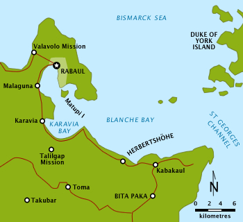
| Description |
English: Simple outline map of Rabaul area, Neu Pommern (New Britain) with nomenclature correct as per 1914. Place names mentioned in the Battle of Bita Paka article are shown. |
| Date | |
| Source |
Own work
|
| Author | Chris Rees w:User:SpoolWhippets |
| Permission (Reusing this file) |
This file is licensed under the Creative Commons Attribution-Share Alike 3.0 Unported license.
|
File history
Click on a date/time to view the file as it appeared at that time.
| Date/Time | Thumbnail | Dimensions | User | Comment | |
|---|---|---|---|---|---|
| current | 11:09, 4 April 2010 | | 350 × 320 (79 KB) | SpoolWhippets | == {{int:filedesc}} == {{Information |Description=Simple outline map of New Guinea and SW Pacific with political borders and nomenclature as prevailed in 1914 at the time of Battle of Bita Paka. Location of battle is highlighted. |Source=Own work<br/> *Da |
File usage
The following pages on the English Wikipedia use this file (pages on other projects are not listed):
Global file usage
The following other wikis use this file:
- Usage on de.wikipedia.org