AtlanticGoodwood_Battle_plan.jpg (263 × 399 pixels, file size: 39 KB, MIME type: image/jpeg)
Summary edit
| Description |
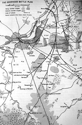
Map showing the planned Anglo-Canadian attacks for Operations Atlantic and Goodwood. Map also shows the confirmed locations of Axis divisions and the areas where others are believed to be. |
|---|---|
| Source |
|
| Article | |
| Portion used |
Only the map from the book was photographed, which has been cropped and a small amount of editing has been done on the photo to make some various bits of the map more clear or readd information lost when the edges were cut. |
| Low resolution? |
Yes |
| Purpose of use |
The image serves as the primary means of visual identification of the subject. What the indended attack routes of the Operation where. |
| Replaceable? |
Similar maps are available online but do not contain same level of detail. |
| Fair useFair use of copyrighted material in the context of Operation Goodwood//en.wikipedia.org/wiki/File:AtlanticGoodwood_Battle_plan.jpgtrue | |
| Description |
Map showing the planned Anglo-Canadian attacks for Operations Atlantic and Goodwood. Map also shows the confirmed locations of Axis divisions and the areas where others are believed to be. |
|---|---|
| Source |
|
| Article | |
| Portion used |
Only the map from the book was photographed, which has been cropped and a small amount of editing has been done on the photo to make some various bits of the map more clear or readd information lost when the edges were cut. |
| Low resolution? |
Yes |
| Purpose of use |
The image serves as the primary means of visual identification of the subject. What the indended attack routes of the Operation where. |
| Replaceable? |
Similar maps are available online but do not contain same level of detail. |
| Fair useFair use of copyrighted material in the context of Operation Atlantic//en.wikipedia.org/wiki/File:AtlanticGoodwood_Battle_plan.jpgtrue | |
Licensing edit
 | This image is a faithful digitisation of a unique historic image, and the copyright for it is most likely held by the person who created the image or the agency employing the person. It is believed that the use of this image may qualify as non-free use under the Copyright law of the United States. Any other uses of this image, on Wikipedia or elsewhere, may be copyright infringement. See Wikipedia:Non-free content for more information. Please remember that the non-free content criteria require that non-free images on Wikipedia must not "[be] used in a manner that is likely to replace the original market role of the original copyrighted media." Use of historic images from press agencies must only be of a transformative nature, when the image itself is the subject of commentary rather than the event it depicts (which is the original market role, and is not allowed per policy). |
| If this tag does not accurately describe this image, please replace it with an appropriate one. | |
File history
Click on a date/time to view the file as it appeared at that time.
| Date/Time | Thumbnail | Dimensions | User | Comment | |
|---|---|---|---|---|---|
| current | 05:07, 27 December 2011 | | 263 × 399 (39 KB) | DASHBot (talk | contribs) | Bot: Rescaling Fair Use Image (shutoff) |
You cannot overwrite this file.