No higher resolution available.
Appalachian-tennessee-arc-2003-status.jpg (344 × 160 pixels, file size: 19 KB, MIME type: image/jpeg)
| This is a file from the Wikimedia Commons. Information from its description page there is shown below. Commons is a freely licensed media file repository. You can help. |
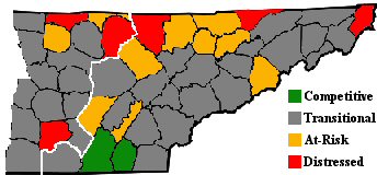
| Description | Map of "Appalachian Tennessee," which includes all counties in East Tennessee and the easternmost counties in Middle Tennessee, showing each county's Appalachian Regional Commission-designated economic status, using 2001-2003 data. The status indicates how the county compares to the national average on unemployment, income per capita, and poverty rate. Counties on par or ahead of the nation on these three indicators are designated "Attainment" (no county in Tennessee received this designation). Counties with unemployment and poverty rate equal or lower than the national average and an income per capita at least 80% of the national average are designated "Competitive" (Hamilton and Bradley counties received this designation). Counties lagging on just one of the three indicators are designated "Transitional." Counties lagging on two of the three indicators are considered "At-Risk." Counties lagging significantly on at least two indicators are considered "Distressed." The white boundary shows the border between East and Middle Tennessee. |
| Date | (UTC) |
| Source | |
| Author |
| This is a retouched picture, which means that it has been digitally altered from its original version. The original can be viewed here: Map of Tennessee highlighting Hancock County.svg:
|
I, the copyright holder of this work, hereby publish it under the following license:
| I, the copyright holder of this work, release this work into the public domain. This applies worldwide. In some countries this may not be legally possible; if so: I grant anyone the right to use this work for any purpose, without any conditions, unless such conditions are required by law. |
Original upload log
This image is a derivative work of the following images:
- File:Map_of_Tennessee_highlighting_Hancock_County.svg licensed with PD-self
- 2006-02-12T16:32:38Z David Benbennick 7814x1916 (100189 Bytes) {{subst:User:Dbenbenn/clm|county=Hancock County|state=Tennessee|type=county}}
Uploaded with derivativeFX
File history
Click on a date/time to view the file as it appeared at that time.
| Date/Time | Thumbnail | Dimensions | User | Comment | |
|---|---|---|---|---|---|
| current | 13:55, 24 August 2009 | | 344 × 160 (19 KB) | BrineStans | {{Information |Description=Map of "Appalachian Tennessee," which includes all counties in East Tennessee and the easternmost counties in Middle Tennessee, showing each county's Appalachian Regional Commission-designated economic status, using 2001-2003 da |
File usage
No pages on the English Wikipedia use this file (pages on other projects are not listed).
Global file usage
The following other wikis use this file:
- Usage on ro.wikipedia.org
- Categorie:Guvernatori ai statului Tennessee
- Categorie:Statul Tennessee, SUA
- Tennessee
- Format:Tennessee stat SUA
- Nashville, Tennessee
- Categorie:Formate Tennessee
- Categorie:Liste Tennessee
- Listă de oameni din statul Tennessee
- Categorie:Guvernul statului Tennessee
- Râul Tennessee
- Categorie:Comitatul Washington, Tennessee
- Categorie:Comitatul Wayne, Tennessee
- McLemoresville, Tennessee
- Listă de comitate din statul Tennessee
- McKenzie, Tennessee
- Categorie:Comitatul Carroll, Tennessee
- Huntingdon, Tennessee
- Categorie:Comitatul Anderson, Tennessee
- Categorie:Comitatul Bedford, Tennessee
- Categorie:Zone metropolitane din Tennessee
- Categorie:Zone micropolitane din Tennessee
- Categorie:Comitatul Benton, Tennessee
- Categorie:Comitatul Warren, Tennessee
- Categorie:Comitatul Fayette, Tennessee
- Categorie:Comitatul Union, Tennessee
- Categorie:Comitatul Lincoln, Tennessee
- Categorie:Comitatul Wilson, Tennessee
- Categorie:Localități din Tennessee
- Categorie:Membri ai Camerei Reprezentanților SUA din statul Tennessee
- Categorie:Orașe din Tennessee
- Categorie:Comitatul White, Tennessee
- Categorie:Comitatul Williamson, Tennessee
- Categorie:Comitatul Weakley, Tennessee
- Categorie:Comitatul Henry, Tennessee
- Categorie:Comitatul Bledsoe, Tennessee
- Pikeville, Tennessee
- Categorie:Comitatul Moore, Tennessee
- Categorie:Comitatul Blount, Tennessee
- Categorie:Comitatul Bradley, Tennessee
- Categorie:Comitatul Van Buren, Tennessee
- Categorie:Comitatul Shelby, Tennessee
- Categorie:Comitatul Scott, Tennessee
- Categorie:Comitatul Madison, Tennessee
- Knoxville, Tennessee
- Categorie:Comitatul Knox, Tennessee
- Categorie:Comitatul Jackson, Tennessee
- Categorie:Comitatul Franklin, Tennessee
- Categorie:Comitatul Johnson, Tennessee
- Categorie:Comitatul Houston, Tennessee
- Categorie:Comitatul Monroe, Tennessee
View more global usage of this file.