
Original file (2,400 × 2,055 pixels, file size: 1.51 MB, MIME type: image/jpeg)
| This is a file from the Wikimedia Commons. Information from its description page there is shown below. Commons is a freely licensed media file repository. You can help. |
Summary
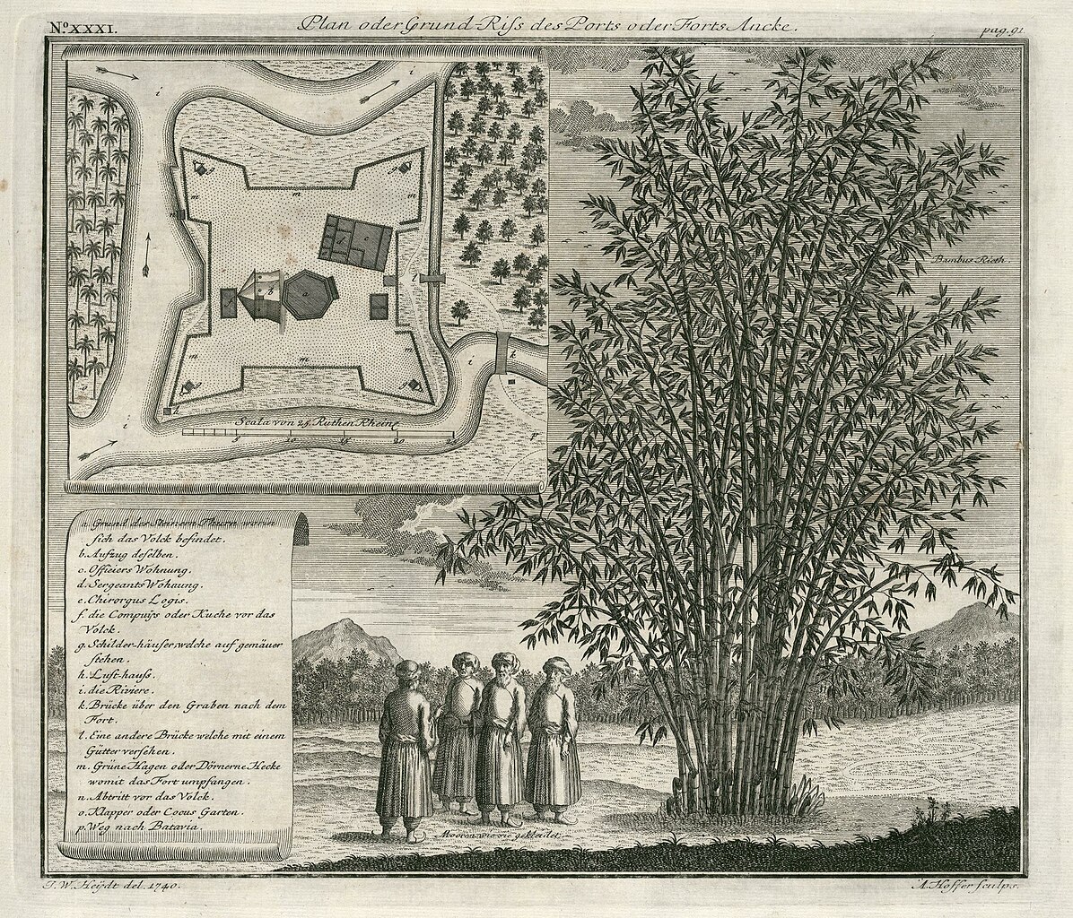
Nederlands: Plattegrond van fort Anké
English: Map of Fort Anké( |
||||||||||||||||||||||||||||||
|---|---|---|---|---|---|---|---|---|---|---|---|---|---|---|---|---|---|---|---|---|---|---|---|---|---|---|---|---|---|---|
| Author |
Nederlands: Johann Wolfgang Heydt (tekenaar), Andreas Hoffer (graveur / etser), Johann Carl Tetschner (uitgever)
English: Johann Wolfgang Heydt (draughtsman), Andreas Hoffer (engraver / etcher), Johann Carl Tetschner (publisher) |
|||||||||||||||||||||||||||||
| Title |
Nederlands: Plattegrond van fort Anké
English: Map of Fort Anké |
|||||||||||||||||||||||||||||
| Description |
Nederlands: Plattegrond van fort Anké.
Plan oder Grund-Riss des Ports oder Forts Ancke. Linksboven: No: XXXI. Rechtsboven: pag. 91.. Legenda: a. Grund des Steinern Thurn worin sich das Volck befindet. / b. Aufzug deselben. / Officiers Wohnung. / d. Sergeants Wohnung. / e. Chirorgus Logis. / f. die Compuijs oder Kuche vor das Volck. / g. Schilder-häufer, welche auf gemäuer stehen. / h. Luft-hauss. / i. die Riviere. / k. Brücle über den Graben nach dem Fort. / l. Eine andere Brücke welche mit einem Gütter versehen. / m. Grüne Hagen oder Dörnerne Hecke womit das Fort umpfangen. / n. Abtritt vor das Volck. / o. Klapper oder Cocus Garten. / p. Weg nach Batavia.. Middenonder, naast de personen: Mooren wie sie gekleidet. Rechtsboven, naast de plant: Bambus Rieth..English: Map of Fort Anké.
Plan oder Grund-Riss des Ports oder Forts Ancke. Top left: No: XXXI. Top right: pag. 91.. Key: a. Grund des Steinern Thurn worin sich das Volck befindet. / b. Aufzug deselben. / Officiers Wohnung. / d. Sergeants Wohnung. / e. Chirorgus Logis. / f. die Compuijs oder Kuche vor das Volck. / g. Schilder-häufer, welche auf gemäuer stehen. / h. Luft-hauss. / i. die Riviere. / k. Brücle über den Graben nach dem Fort. / l. Eine andere Brücke welche mit einem Gütter versehen. / m. Grüne Hagen oder Dörnerne Hecke womit das Fort umpfangen. / n. Abtritt vor das Volck. / o. Klapper oder Cocus Garten. / p. Weg nach Batavia.. Bottom centre, alongside the figures: Mooren wie sie gekleidet. Top right, next to the plant: Bambus Rieth.. |
|||||||||||||||||||||||||||||
| Date | 1740 | |||||||||||||||||||||||||||||
| Medium |
Nederlands: koperdruk op papier
English: copperplate printing on paper |
|||||||||||||||||||||||||||||
| Dimensions | height: 29 cm (11.4 in); width: 25 cm (9.8 in) | |||||||||||||||||||||||||||||
| Collection |
|
|||||||||||||||||||||||||||||
| Accession number |
2102 A 7 p. 91 |
|||||||||||||||||||||||||||||
| Inscriptions |
Plan oder Grund-Riss des Ports oder Forts Ancke
author: J. W. Heijdt del. 1740. / A. Hoffer sculps. |
|||||||||||||||||||||||||||||
| Notes |
English: Subjects: survey / view, chart / map / plan, key, banderole / cartouche / ornamentation, Person, Asians & Africans, fortification, building, flora, bird's-eye view / elevation, elevation / bird's-eye view, tower
Nederlands: Onderwerpen: overzicht / aanzicht, plattegrond / kaart, legenda, banderol / cartouche / versiering, Persoon, Aziaten & Afrikanen, vesting, gebouw, flora, vogelvlucht / opstand, opstand / vogelvlucht, toren
English: Post: this image is related to a VOC trading post called Anckee |
|||||||||||||||||||||||||||||
| Source/Photographer |
|
|||||||||||||||||||||||||||||
| Permission (Reusing this file) |
|
|||||||||||||||||||||||||||||

| Object location | | View this and other nearby images on: OpenStreetMap |
|---|
File history
Click on a date/time to view the file as it appeared at that time.
| Date/Time | Thumbnail | Dimensions | User | Comment | |
|---|---|---|---|---|---|
| current | 12:15, 10 June 2014 | | 2,400 × 2,055 (1.51 MB) | HuskyBot | == {{int:filedesc}} == {{Artwork |title = {{nl|1=Plattegrond van fort Anké}} {{en|1=Map of Fort Anké}} |description = {{nl|1=Plattegrond van fort Anké. ''Plan oder Grund-Riss des Ports oder Forts Ancke''.... |
File usage
Global file usage
The following other wikis use this file:
- Usage on ar.wikipedia.org
- Usage on fr.wikipedia.org
- Usage on id.wikipedia.org
- Usage on ml.wikipedia.org
- Usage on nl.wikipedia.org
- Usage on www.wikidata.org