File:1857 U.S. Coast Survey Map or Chart of the Entrance to the York River, Virginia - Geographicus - YorkRiver-uscs-1857.jpg

Original file (3,000 × 2,277 pixels, file size: 1.31 MB, MIME type: image/jpeg)
| This is a file from the Wikimedia Commons. Information from its description page there is shown below. Commons is a freely licensed media file repository. You can help. |
| Preliminary Chart of York River Virginia from Entrance to Kings Creek. | ||||||
|---|---|---|---|---|---|---|
| Artist | ||||||
| Title |
Preliminary Chart of York River Virginia from Entrance to Kings Creek. |
|||||
| Description |
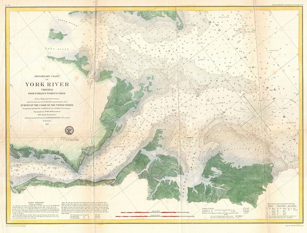
English: An attractive hand colored 1857 U.S. Coast Survey nautical chart or map of Virginia’s York River. Covers the course of the York River from its entrance at the Chesapeake Bay to King Creek. Offers countless depth soundings, sailing instructions, and navigational notes, as well as considerable inland detail. Identifies Yorktown, Gloucester Point, and a number of other important sites. The York River was an important theater in the American Revolutionary war and it is here, at Yorktown, where the British formally surrendered. The hand color work on this beautiful map is exceptionally well done. The triangulation for this chart was accomplished by E. Blunt, J. Farley and J. P. Roy. The Topography is the work of John Seib. The Hydrography was completed by a party under the command of J. J. Almy and R. D. Minor. Compiled under the direction of A. D. Bache, Superintendent of the Survey of the Coast of the United States and one of the most influential American cartographers of the 19th century. |
|||||
| Date | 1857 (dated) | |||||
| Dimensions | height: 17 in (43.1 cm); width: 23 in (58.4 cm) | |||||
| Accession number |
Geographicus link: YorkRiver-uscs-1857 |
|||||
| Source/Photographer |
Report of the Superintendant of the United States Coast Survey, Washington, (1857 edition).
|
|||||
| Permission (Reusing this file) |
|
|||||
| Object location | | View this and other nearby images on: OpenStreetMap |
|---|
File history
Click on a date/time to view the file as it appeared at that time.
| Date/Time | Thumbnail | Dimensions | User | Comment | |
|---|---|---|---|---|---|
| current | 00:07, 24 March 2011 | | 3,000 × 2,277 (1.31 MB) | BotMultichillT | {{subst:User:Multichill/Geographicus |link=http://www.geographicus.com/P/AntiqueMap/YorkRiver-uscs-1857 |product_name=1857 U.S. Coast Survey Map or Chart of the Entrance to the York River, Virginiaq |map_title=Preliminary Chart of York River Virginia from |