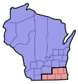
File:1848 Wisconsin Congressional Districts.svg

Original file(SVG file, nominally 454 × 489 pixels, file size: 43 KB)

Summary

Description
English: Original Wisconsin congressional districts as defined in the 1848 Wisconsin Constitution.

1st district: Milwaukee, Waukesha, Jefferson, Racine, Walworth, Rock, and Green counties

2nd district: Washington, Sheboygan, Manitowoc, Calumet, Brown, Winnebago, Fond du Lac, Marquette, Sauk, Portage, Columbia, Dodge, Dane, Iowa, La Fayette, Grant, Richland, Crawford, Chippewa, St. Croix, and La Pointe counties
Date
Source Own work
Author Asdasdasdff

Licensing

I, the copyright holder of this work, hereby publish it under the following license:
w:en:Creative Commons
attribution share alike
This file is licensed under the Creative Commons Attribution-Share Alike 4.0 International license.
You are free:
  • to share – to copy, distribute and transmit the work
  • to remix – to adapt the work
Under the following conditions:
  • attribution – You must give appropriate credit, provide a link to the license, and indicate if changes were made. You may do so in any reasonable manner, but not in any way that suggests the licensor endorses you or your use.
  • share alike – If you remix, transform, or build upon the material, you must distribute your contributions under the same or compatible license as the original.

Captions

1848 Wisconsin congressional districts

10 January 2021

image/svg+xml

5a0b14e126cfea36964072fb086ebb159788b3c5

44,344 byte

489 pixel

454 pixel

File history

Click on a date/time to view the file as it appeared at that time.

Date/TimeThumbnailDimensionsUserComment
current17:29, 14 January 2021Thumbnail for version as of 17:29, 14 January 2021454 × 489 (43 KB)Asdasdasdfffixing transparency issue in 1 county
17:23, 14 January 2021Thumbnail for version as of 17:23, 14 January 2021454 × 489 (44 KB)Asdasdasdffcolor to differentiate districts instead of ugly numbers
20:10, 10 January 2021Thumbnail for version as of 20:10, 10 January 2021454 × 489 (45 KB)Asdasdasdffredrew the marquette boundary to make it a bit more accurate
19:51, 10 January 2021Thumbnail for version as of 19:51, 10 January 2021454 × 489 (44 KB)AsdasdasdffUploaded own work with UploadWizard
The following pages on the English Wikipedia use this file (pages on other projects are not listed):

Metadata