
Size of this preview: 800 × 533 pixels. Other resolutions: 320 × 213 pixels | 640 × 427 pixels | 1,024 × 683 pixels | 1,280 × 853 pixels | 2,560 × 1,706 pixels | 4,573 × 3,048 pixels.
Original file (4,573 × 3,048 pixels, file size: 9.2 MB, MIME type: image/jpeg)
| This is a file from the Wikimedia Commons. Information from its description page there is shown below. Commons is a freely licensed media file repository. You can help. |
Summary
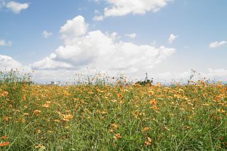
| Description | 橋牟礼川遺跡 | ||
| Date | Taken on 2 September 2008 | ||
| Source | https://web.archive.org/web/20161025163927/http://www.panoramio.com/photo/77282215 | ||
| Author | shikabane taro | ||
| Permission (Reusing this file) |
This file is licensed under the Creative Commons Attribution 3.0 Unported license. Attribution: shikabane taro
|
||
| Tags (from Panoramio photo page) | Ibusuki, 坊津まで |
| Camera location | | View this and other nearby images on: OpenStreetMap |
|---|
File history
Click on a date/time to view the file as it appeared at that time.
| Date/Time | Thumbnail | Dimensions | User | Comment | |
|---|---|---|---|---|---|
| current | 09:10, 18 January 2017 | | 4,573 × 3,048 (9.2 MB) | Panoramio upload bot | == {{int:filedesc}} == {{Information |description=橋牟礼川遺跡 |date={{Taken on|2008-09-02}} |source=http://www.panoramio.com/photo/77282215 |author=[http://www.panoramio.com/user/3658107?with_photo_id=77282215 shikabane taro] |permission={{cc-by... |
File usage
The following pages on the English Wikipedia use this file (pages on other projects are not listed):