Ephraim (/ˈiːfrɑːm/ EEF-rahm)[6] is a village in Door County, Wisconsin, United States. It is located across Eagle Harbor from Peninsula State Park.[7] The population was 288 at the 2010 census. The village is known for its white buildings, its views of the bluffs across Eagle Harbor, and its shoreline along Green Bay.
Ephraim, Wisconsin | |
|---|---|
 | |
 Location of Ephraim in Door County, Wisconsin. | |
| Coordinates: 45°9′23″N 87°10′16″W / 45.15639°N 87.17111°W | |
| Country | |
| State | |
| County | Door |
| Area | |
| • Total | 8.13 sq mi (21.06 km2) |
| • Land | 3.79 sq mi (9.81 km2) |
| • Water | 4.34 sq mi (11.25 km2) |
| Elevation | 663 ft (202 m) |
| Population | |
| • Total | 288 |
| • Estimate (2019)[4] | 280 |
| • Density | 73.94/sq mi (28.55/km2) |
| Time zone | UTC-6 (Central (CST)) |
| • Summer (DST) | UTC-5 (CDT) |
| Area code | 920 |
| FIPS code | 55-24150[5] |
| GNIS feature ID | 1564680[2] |
| Website | www |
History edit
The village was founded in 1853 by the Reverend Andreas Iverson as a Moravian religious community.[8] The steeples of the Ephraim Moravian Church and the Free Evangelical Lutheran Church-Bethania Scandinavian Evangelical Lutheran Congregation are the landmarks of the village as seen from Eagle Harbor. The home of Reverend Iverson, as well as the Anderson Store, the Anderson Barn and History Center, the Pioneer Schoolhouse and the Goodletson log cabin are preserved by the Ephraim Historical Foundation and open to visitors as museums. The Ephraim Historical Foundation also offers walking tours of the village.

Since its founding, the village prohibited alcohol sales or manufacture within the village; it was, until 2016, the only dry municipality in the state of Wisconsin. There were two referendums concerning the sale of liquor within the village, in 1934 and 1992. Both times the citizenry voted decisively to keep the village dry (with majorities of 59% and 74%, respectively).[9] On April 5, 2016, village residents voted on two separate referendums to allow beer and/or wine sales within the village, both of which passed by 56% and 68% majorities.[10]
Geography edit
![The village limits of Ephraim reach from inside the eastern portion of Peninsula State Park (far left) to the more developed area along Eagle Harbor (center) to the western portion of Little Sister Bay (far right)[11]](/wiki/File:Eagle_Harbor,_Door_County,_Wisconsin.png)
To the west is Peninsula State Park; to the east and south are unincorporated parts of the town of Gibraltar. Ephraim is located at 45°9′23″N 87°10′16″W / 45.15639°N 87.17111°W (45.156509, -87.171047).[12]
According to the United States Census Bureau, the village has a total area of 7.16 square miles (18.54 km2), of which, 3.79 square miles (9.82 km2) of it is land and 3.37 square miles (8.73 km2) is water.[13]
The highest point in the village (at the north end of North Orchard St.) is about 788 feet (240 m) above sea level, or 210 feet (64 m) above the surface of Green Bay.
Climate edit
The climate in Ephraim is temperate, with warm summers and cold winters.
| Peninsular Agricultural Research Station north of Sturgeon Bay | ||||||||||||||||||||||||||||||||||||||||||||||||||||||||||||
|---|---|---|---|---|---|---|---|---|---|---|---|---|---|---|---|---|---|---|---|---|---|---|---|---|---|---|---|---|---|---|---|---|---|---|---|---|---|---|---|---|---|---|---|---|---|---|---|---|---|---|---|---|---|---|---|---|---|---|---|---|
| Climate chart (explanation) | ||||||||||||||||||||||||||||||||||||||||||||||||||||||||||||
| ||||||||||||||||||||||||||||||||||||||||||||||||||||||||||||
| ||||||||||||||||||||||||||||||||||||||||||||||||||||||||||||
Demographics edit
2010 census edit
| Census | Pop. | Note | %± |
|---|---|---|---|
| 1920 | 196 | — | |
| 1930 | 191 | −2.6% | |
| 1940 | 254 | 33.0% | |
| 1950 | 244 | −3.9% | |
| 1960 | 221 | −9.4% | |
| 1970 | 236 | 6.8% | |
| 1980 | 319 | 35.2% | |
| 1990 | 261 | −18.2% | |
| 2000 | 353 | 35.2% | |
| 2010 | 288 | −18.4% | |
| 2019 (est.) | 280 | [4] | −2.8% |
| U.S. Decennial Census[14] | |||
As of the census[3] of 2010, there were 288 people, 138 households, and 92 families residing in the village. The population density was 76.0 inhabitants per square mile (29.3/km2). There were 654 housing units at an average density of 172.6 per square mile (66.6/km2). The racial makeup of the village was 99.0% White, 0.3% Native American, and 0.7% from other races. Hispanic or Latino of any race were 2.4% of the population.
There were 138 households, of which 17.4% had children under the age of 18 living with them, 56.5% were married couples living together, 7.2% had a female householder with no husband present, 2.9% had a male householder with no wife present, and 33.3% were non-families. 27.5% of all households were made up of individuals, and 15.9% had someone living alone who was 65 years of age or older. The average household size was 2.09 and the average family size was 2.52.
The median age in the village was 58.8 years. 14.9% of residents were under the age of 18; 2.5% were between the ages of 18 and 24; 16.7% were from 25 to 44; 33% were from 45 to 64; and 33% were 65 years of age or older. The gender makeup of the village was 46.9% male and 53.1% female.
2000 census edit
As of the census[5] of 2000, there were 353 people, 161 households, and 112 families residing in the village. The population density was 90.6 people per square mile (34.9/km2). There were 771 housing units at an average density of 197.8 per square mile (76.3/km2). The racial makeup of the village was 99.15% White, and 0.85% from two or more races. Hispanic or Latino of any race were 0.28% of the population.
There were 161 households, out of which 18.0% had children under the age of 18 living with them, 63.4% were married couples living together, 3.1% had a female householder with no husband present, and 30.4% were non-families. 27.3% of all households were made up of individuals, and 14.3% had someone living alone who was 65 years of age or older. The average household size was 2.19 and the average family size was 2.62.

In the village, the population was spread out, with 19.0% under the age of 18, 2.5% from 18 to 24, 17.6% from 25 to 44, 32.9% from 45 to 64, and 28.0% who were 65 years of age or older. The median age was 53 years. For every 100 females, there were 85.8 males. For every 100 females age 18 and over, there were 81.0 males.
The median income for a household in the village was $52,500, and the median income for a family was $60,227. Males had a median income of $37,813 versus $31,875 for females. The per capita income for the village was $30,579. About 2.7% of families and 5.2% of the population were below the poverty line, including 15.8% of those under age 18 and 3.2% of those age 65 or over.
Events edit
The village's main festival is Fyr Bal, a Scandinavian celebration held near the solstice in mid-June to drive out the wicked winter witch. Each year a person is assigned the role of Chieftain. At sunset, this Chieftain travels across Eagle Harbor via a pontoon boat and once they land in Ephraim, lights a large bonfire. Bonfires burn along the shoreline as residents and visitors gather to celebrate the beginning of summer.
Education edit
Gibraltar Area Schools serves the community. Gibraltar Elementary School[15] and Gibraltar Secondary School[16] are the two schools.
Notable people edit
- Bert D. Thorp, Wisconsin State Assembly and businessman, lived in Ephraim; he served as president of the village of Ephraim.[17]
Images edit
-
 View of Ephraim from the former Eagle tower in Peninsula State Park
 -

-

-
 Post office
 -
 Fire station
 -
![Anderson Dock; graffiti is permitted on the warehouse building within certain limits.[18]](//upload.wikimedia.org/wikipedia/commons/thumb/1/15/The_Anderson_Dock_in_Ephraim%2C_Door_County%2C_Wisconsin%2C_site_of_the_Hardy_Gallery.jpg/359px-The_Anderson_Dock_in_Ephraim%2C_Door_County%2C_Wisconsin%2C_site_of_the_Hardy_Gallery.jpg) Anderson Dock; graffiti is permitted on the warehouse building within certain limits.[18]
Anderson Dock; graffiti is permitted on the warehouse building within certain limits.[18] -
![Breakwater near Anderson Dock; graffiti is not permitted on the breakwater.[19]](//upload.wikimedia.org/wikipedia/commons/thumb/d/d5/Vandalized_breakwater_near_the_Anderson_Dock_in_Ephraim%2C_Door_County%2C_Wisconsin.jpg/359px-Vandalized_breakwater_near_the_Anderson_Dock_in_Ephraim%2C_Door_County%2C_Wisconsin.jpg) Breakwater near Anderson Dock; graffiti is not permitted on the breakwater.[19]
Breakwater near Anderson Dock; graffiti is not permitted on the breakwater.[19] -
 Park
Park -
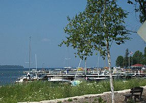 View of marina from Highway 42
 -
 The golf course inside Peninsula State Park is within Ephraim village limits
 -
 Car near the top of a dirt road near Ephraim; from a postcard postmarked in 1916


![Anderson Dock; graffiti is permitted on the warehouse building within certain limits.[18]](/wiki/File:The_Anderson_Dock_in_Ephraim,_Door_County,_Wisconsin,_site_of_the_Hardy_Gallery.jpg)
![Breakwater near Anderson Dock; graffiti is not permitted on the breakwater.[19]](/wiki/File:Vandalized_breakwater_near_the_Anderson_Dock_in_Ephraim,_Door_County,_Wisconsin.jpg)


References edit
- ^ "2019 U.S. Gazetteer Files". United States Census Bureau. Retrieved August 7, 2020.
- ^ a b "US Board on Geographic Names". United States Geological Survey. October 25, 2007. Retrieved January 31, 2008.
- ^ a b "U.S. Census website". United States Census Bureau. Retrieved November 18, 2012.
- ^ a b "Population and Housing Unit Estimates". United States Census Bureau. May 24, 2020. Retrieved May 27, 2020.
- ^ a b "U.S. Census website". United States Census Bureau. Retrieved January 31, 2008.
- ^ MissPronouncer.com: A HALFWAY DECENT AUDIO PRONUNCIATION GUIDE FOR WISCONSIN
- ^ Map of the Village of Ephraim, Door County Land Use Services Department, March 1, 2018 (Archived April 9, 2019)
- ^ Chapter 34: Ephraim in History of Door County, Wisconsin by Hjalmar R. Holand, 1917, pages 333–334
- ^ Village Website
- ^ Roberts, Rhonda (April 6, 2016). "After 163 years, Door County's Ephraim no longer dry". WBAY-TV, Green Bay. Archived from the original on April 18, 2016. Retrieved April 6, 2016.
- ^ Web-Map of Door County, Wisconsin ... For All Seasons!, Door County Land Information Office
- ^ "US Gazetteer files: 2010, 2000, and 1990". United States Census Bureau. February 12, 2011. Retrieved April 23, 2011.
- ^ "US Gazetteer files 2010". United States Census Bureau. Archived from the original on January 25, 2012. Retrieved November 18, 2012.
- ^ "Census of Population and Housing". Census.gov. Retrieved June 4, 2015.
- ^ Gibraltar Elementary School Archived May 3, 2022, at the Wayback Machine, gibraltar.k12.wi.us
- ^ Gibraltar Elementary School Archived May 3, 2022, at the Wayback Machine, gibraltar.k12.wi.us
- ^ 'Wisconsin Blue Book1925,' Biographical Sketch of Bert D. Thorp, pg. 661
- ^ What’s With the Graffiti at Anderson Dock? by Maddy Schierl, Door County Living, December 18, 2019
- ^ Anderson Dock to get facelift, doorcountydailynews.com, March 14, 2022
External links edit
- Village website
- Ephraim Historical Foundation
- Fish Creek & Ephraim tour video, Around the Corner with John McGivern, Episode #612, PBS (Archived April 19, 2020)
- Ephraim, 1853-1953 by Arthur F. Byfield, Men's Club of Ephraim, Wisconsin, link starts at the table of contents