The N1 or Dhaka–Chittagong Highway is the main transportation artery of Bangladesh, connecting the capital city of Dhaka and the southern port city of Chittagong.[2] Approximately 465 kilometres (289 miles) in length, the highway starts at Jatrabari in Dhaka and ends at Teknaf in Cox's Bazar.[3][4][5] The highway is known along certain stretches as the Chittagong–Cox's Bazar Highway[6] and the Cox's Bazar–Teknaf Highway.[7]
 | ||||
|---|---|---|---|---|
| Dhaka–Chattogram Highway,
Chattogram- Cox's Bazar Highway , Cox's Bazar - Teknaf Highway | ||||
 Map of the National Highway 1 in red | ||||
| Route information | ||||
| Part of | ||||
| Length | 465 km[1] (289 mi) | |||
| Major junctions | ||||
| Dhaka end | Saidabad Connecting with Jatrabari Flyover | |||
List
| ||||
| To | Teknaf , Cox's Bazar | |||
| Location | ||||
| Country | Bangladesh | |||
| Highway system | ||||
| ||||
Currently four lanes with an eight-lane expansion underway, the N1 is the busiest road in the country and a top development priority.[3]
Background edit
When constructed, the highway was limited to two lanes of traffic for most of its length. Traffic jams or tailbacks of 25 kilometres (16 miles) have been reported.[8] In 2009, it was estimated that daily usage of the highway was 20,000–25,000 motorised vehicles, up 40% of which were trucks.[3]
The highway forms a critical component of the proposed Asian Highway Network route AH41 and the Central-South-East Asian economic corridor, including initiatives such as BCIM.[citation needed]
Expansion and development edit
Dhaka–Chittagong highway edit
Four lanes edit

In January 2010, construction work to expand the Dhaka–Chittagong stretch from two to four lanes commenced.[9] The project was expected to decrease travel time from Dhaka to Chittagong to 4.5 or 5 hours.[4]
As of March 2013, only 23.5 per cent of work has been completed, and it was unlikely to meet its December 2013 deadline. Construction included 221 culverts, 22 bridges and three flyovers.[10] Reza Construction Ltd. and Sino Hydro have set temporary camps for this purpose respectively near Daudkandi and Chandina in Comilla District.[1]
After inauguration being postponed several times, the project, implemented by the Roads and Highways Department (RHD), was finally completed and opened on 2 July 2016, three years behind schedule and a full decade after the plan was approved.[11][12]
The total cost for the expansion of the stretch was ৳3817 crore (US$360 million), up from the initial estimate of ৳2161 crore (US$200 million) in 2006.[13]
Eight lanes edit
An upgrade of the Dhaka–Chittagong section to eight lanes to start construction by late 2024 or early 2025 is on the cards. Portions of the 229-kilometre (142 mi) road will be converted into six lanes, while others will be expanded to eight lanes. The total cost of the project is estimated at ৳73150 crore (US$6.8 billion). The Asian Development Bank (ADB) will provide financing for this project—which is going to be implemented in three phases—according to the RHD.[14][15]
Chittagong–Cox's Bazar highway edit
Bypass lanes edit
The RHD is planning to alleviate traffic congestion on the Chittagong–Cox's Bazar route by constructing bypass lanes and flyovers at five crucial points. This initiative is prompted by the upcoming opening of the Matarbari Deep Sea Port in 2026, which is anticipated to increase traffic on the current two-lane highway. The project includes the construction of four-lane bypasses at Patiya (5.4 kilometres (3.4 mi)), Dohazari (3.3 kilometres (2.1 mi)), Lohagara (5.1 kilometres (3.2 mi)), and Chakaria (6.8 kilometres (4.2 mi)), along with a six-lane flyover at Keranihat (3.5 kilometres (2.2 mi)).[16]
Four lanes edit
The RHD is also upgrading the Chittagong–Cox's Bazar highway to four lanes, at an initial estimated cost of ৳18000 crore (US$1.7 billion). This project aims to expand 110 kilometres (68 mi) of the 169 kilometres (105 mi) highway into four lanes, as sections of the highway have already been upgraded earlier.[15]
Route description edit
This section needs additional citations for verification. (April 2024) |
In Dhaka District edit
From Jatrabari to Signboard 6 km in Dhaka District.
In Narayanganj District edit
This highway runs on three Upazilas of Narayangaj district. Upazilas are Narayanganj Sadar Upazila, Bandar Upazila and Sonargaon Upazila. From Signboard to Meghna Bridge, total length of N1 highway runs on this district is 19 km.
In Munshiganj District edit
The highway exceeded only one Upazila of Munshiganj district and that is Gazaria Upazila. From Meghna Bridge to Meghna-Gomti bridge, total length of highway runs on this district is 11 km.
In Comilla District edit
N1 exceeds five Upazilas of Comilla district, Daudkandi Upazila, Chandina Upazila, Burichang Upazila, Comilla Sadar Upazila and Chauddagram Upazila. Length of N1 in Comilla district is 97 km.
In Feni District edit
N1 exceeded two Upazila of Feni district, Feni Sadar Upazila and Chhagalnaiya Upazila. Length of N1 in Feni district is 31 km.
In Chittagong District edit
N1 exceeds seven upazilas on Chittagong district including Chittagong city. Upazilas are Mirsharai Upazila, Sitakunda Upazila, Boalkhali Upazila, Patiya Upazila, Chandanaish Upazila, Satkania Upazila and Lohagara Upazila. Length of N1 in Chittagong District is 148.06 km.
In Cox's Bazar District edit
N1 exceeds four upazilas of Cox's bazar district. Upazilas are Chakaria Upazila, Ramu Upazila, Ukhia Upazila and Teknaf Upazila. Length of N1 in Cox's Bazar District is 148.87 km. [5]
Gallery edit
-
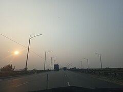
 N1 toward Chakoria, Cox's Bazar
 -
 at Chouddogram, Comilla.
 -
 at Elliotganj, Comilla.
 -
 Chittagong Bypass, connects Port of Chittagong with Dhaka–Chittagong Highway, through Patenga
 -
 Dhaka–Chittagong Highway.
 -
 At Bhatiary
 -


See also edit
References edit
- ^ a b "Road Master Plan" (PDF). Bangladesh Roads and Highways Department. Retrieved 12 December 2012.
- ^ Ullah, Mohammad Ahad; Nikraz, Dr Hamid; Hoque, Dr Md Shamsul (2016). "Study on historical commuter traffic pattern of Dhaka-Chittagong Highway (NH-1) of Bangladesh". International Journal of Civil Engineering and Technology. 7 (3): 136–144.
- ^ a b c "Proposed Technical Assistance Loan People's Republic of Bangladesh:Dhaka–Chittagong Expressway Public–Private Partnership Design Project" (PDF). 2011. Retrieved 12 April 2015.
- ^ a b Daily Industry (16 February 2015). "Dhaka-Ctg 4-lane to be completed by June". Daily Industry. Retrieved 16 October 2015.
- ^ a b "N1: Online Road Network". Roads and Highways Department. Retrieved 14 April 2024.
- ^ "Contract Signing Ceremony: Construction of 8 km Approach Road (4-Lane) and Structures under Third Karnaphuli Bridge Project (New Scope of Works)" (PDF). Roads and Highways Department. 6 March 2017. Retrieved 14 April 2024.
- ^ "BANGLADESH: Emergency Assistance Project: Improvement of National Highway (N1) From Link Road (Cox's Bazar) To Teknaf" (PDF). Asian Development Bank. February 2019. Retrieved 14 April 2024.
- ^ Daily Star (15 July 2015). "Long tailback on Dhaka-Ctg highway". Daily Star Online. Retrieved 16 October 2015.
- ^ "RHD misses target of bitumen work". The Financial Express. 11 February 2013. Retrieved 8 March 2013.
- ^ "4-lane Dhaka-Chittagong Highway to miss deadline". New Age. 13 January 2013. Retrieved 8 March 2013.
- ^ Karim, Mohosinul (26 June 2013). "Dhaka-Chittagong highway work won't finish this term". Dhaka Tribune. Retrieved 5 April 2024.
- ^ Tusher, Hasan Jahid (2 July 2016). "Dream highway stirs new hope". The Daily Star. Retrieved 5 April 2024.
- ^ "Dhaka-Chittagong four-lane highway project cost goes up by 77%". Dhaka Tribune. 16 February 2016. Retrieved 5 April 2024.
- ^ "Dhaka-Ctg road to have eight lanes". The Financial Express. Retrieved 6 April 2024.
- ^ a b "Dhaka-Ctg 8-lane highway project to begin by end-2024". The Business Standard. 12 March 2023. Retrieved 6 April 2024.
- ^ Adhikary, Tuhin Shubhra (29 March 2023). "Ctg-Cox's Bazar Highway: RHD moves to get rid of bottlenecks". The Daily Star. Retrieved 5 April 2024.