Cottonwood River is one of the principal tributaries of the Neosho River in central Kansas of the United States.[4]
| Cottonwood River | |
|---|---|
 1886 Clements Stone Arch Bridge over Cottonwood River near Clements (2006) | |
| Location | |
| Country | United States |
| State | Kansas |
| Region | Flint Hills |
| Physical characteristics | |
| Source | |
| • location | West of Marion, Kansas |
| • coordinates | 38°21′25″N 097°04′14″W / 38.35694°N 97.07056°W[1] |
| • elevation | 1,056 ft (322 m) |
| Mouth | Neosho River |
• location | East of Emporia, Kansas |
• coordinates | 38°23′09″N 096°03′23″W / 38.38583°N 96.05639°W[1] |
• elevation | 322 ft (98 m)[1] |
| Basin size | 1,912 sq mi (4,950 km2)[2] |
| Discharge | |
| • location | Neosho Rapids[3] |
| • average | 1,239 cu ft/s (35.1 m3/s)[3] |
| Basin features | |
| River system | Neosho River |
Course edit
The river begins near the west line of Marion County as two tributaries, the North Cottonwood River and the South Cottonwood River. They both start within 2 miles of each other, and within a few miles northwest of Lehigh.[5]
The North Cottonwood starts near the west line of Marion County,[5] crosses into McPherson County and roughly parallels the county line northward for 5 miles, then crosses back into Marion County.[6] It flows through Durham then into the Marion Reservoir.[5]
The South Cottonwood also starts near the west line of Marion County, flows southward about 1 mile west of Lehigh, then flows eastward about 2 miles south of Hillsboro, then northeast towards the lower side of the Marion Reservoir.[5]
The North and South Cottonwood join about 1 mile southeast of the Marion Reservoir to become the North Fork Cottonwood River, before flowing through the city of Marion.[5] The river flows southeast to Florence, then eastward towards Chase County.[7] In Chase County, it flows northeast through Cedar Point then near Clements and Elmdale. It then flows eastward through Strong City, Cottonwood Falls.[7]
The South Fork Cottonwood River starts south of Matfield Green, then flows northward along the east side of Matfield Green and Bazaar. It merges with the North Fork Cottonwood River about 3 miles east of Cottonwood Falls[7] then flows eastward near Saffordville and across into Lyon County near Plymouth, Kansas, then along the south edge of Emporia. It flows into the Neosho River about 5 miles east of Emporia.[8]
History edit
In 1806, Zebulon Pike led the Pike Expedition westward from St Louis, Missouri, of which part of their journey followed the Cottonwood River through Marion County near the current towns of Florence, Marion, Durham.[9]
Cities and towns along the river edit
Tributaries edit
- Cedar Creek
- Diamond Creek
- Doyle Creek
- Jacobs Creek
Lakes edit
The following lakes are located in the Cottonwood River drainage basin:
- Marion Reservoir, northwest of Marion.
- Marion County Lake, southeast of Marion.
- Chase County State Lake, west of Cottonwood Falls.
- Camp Wood YMCA Lake, south of Elmdale.
- Peabody Country Club Lake, south of Peabody.
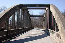
Bridges edit
The following bridges over the Cottonwood River are on the National Register of Historic Places list:
- 1916 Cottonwood River Pratt Truss Bridge, 0.8 miles west of Cedar Point (38°15′36″N 96°50′02″W / 38.26°N 96.833889°W).[10][11]
- 1886 Clements Stone Arch Bridge, 0.5 miles southeast of Clements (38°17′42″N 96°44′05″W / 38.295°N 96.734722°W).[12][13]
- 1914 Cottonwood River Bridge, north edge of Cottonwood Falls (38°22′30″N 96°32′26″W / 38.375°N 96.540556°W).[14][15]
- 1923 Soden's Grove Bridge, south edge of Emporia (38°23′09″N 96°10′54″W / 38.385833°N 96.181667°W).[16][17]
Gallery edit
-
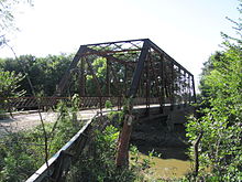 1916 Cottonwood River Pratt Truss Bridge west of Cedar Point (2012)
 -
 Cedar Point Mill in Cedar Point (2012)
 -
 1914 Cottonwood River Bridge in Cottonwood Falls (2012)
 -
 1923 Soden's Grove Bridge over Cottonwood River in Emporia (2005)


See also edit
References edit
- ^ a b c "Cottonwood River". Geographic Names Information System. United States Geological Survey, United States Department of the Interior. 1978-10-13. Retrieved 2013-08-17.
- ^ http://wdr.water.usgs.gov/wy2012/pdfs/07182280.2012.pdf [bare URL PDF]
- ^ a b "USGS Current Conditions for USGS 07182280 COTTONWOOD R NR NEOSHO RAPIDS, KS".
- ^ Kansas : A Cyclopedia of State History, Embracing Events, Institutions, Industries, Counties, Cities, Towns, Prominent Persons, Etc; Frank W. Blackmar; Standard Publishing Co; 1912. Archived 2012-05-11 at the Wayback Machine
- ^ a b c d e Marion County Map; KDOT.
- ^ McPherson County Map; KDOT.
- ^ a b c Chase County Map; KDOT.
- ^ Lyon County Map; KDOT.
- ^ "1806 Pike Expedition map through Marion County" (PDF). Archived from the original (PDF) on 2012-03-17. Retrieved 2012-04-13.
- ^ Cottonwood River Pratt Truss Bridge - NRHP Application
- ^ Cottonwood River Pratt Truss Bridge - NRHP Photos
- ^ Clements Stone Arch Bridge - NRHP Application
- ^ Clements Stone Arch Bridge - NRHP Photos
- ^ Cottonwood River Bridge - NRHP Application
- ^ Cottonwood River Bridge - NRHP Photos
- ^ Soden's Grove Bridge - NRHP Application
- ^ Soden's Grove Bridge - NRHP Photos
External links edit
- Cottonwood River current depth and history
- west edge of Marion
- 1 mile east of Florence
- 1 mile southwest of Plymouth (between Strong City and Emporia)
- 4 miles east of Emporia