This article needs additional citations for verification. (December 2014) |
The Cheremosh River (Ukrainian: Черемош, Romanian: Ceremuș, Polish: Czeremosz) is a river in western Ukraine, right-bank tributary of the river Prut.[1]
| Cheremosh | |
|---|---|
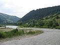
 Cheremosh in Vyzhnytsia Raion | |
| Location | |
| Country | Ukraine |
| Physical characteristics | |
| Mouth | |
• location | Prut at Nepolokivtsi |
• coordinates | 48°22′44″N 25°37′14″E / 48.3789°N 25.6206°E |
| Length | 80 km (50 mi) |
| Basin features | |
| Progression | Prut→ Danube→ Black Sea |
| Tributaries | |
| • left | Chornyi Cheremosh |
| • right | Bilyi Cheremosh, Putylka |
Description edit
It is formed by confluence of two upper streams of the river Bilyi Cheremosh (White Cheremosh) and Chornyi Cheremosh (Black Cheremosh) near the village Usteriky (Verkhovyna Raion) and has a length of 80 km (50 mi).[1][2] Chornyi Cheremosh is 87 km long with a basin of 856 km2 and Bilyi Cheremosh is 61 km long with a basin of 606 km2.[1] The river starts in the Carpathian Mountains and flows roughly SW to NE. It leaves the Bukovina Obchinas (a mountain range in Outer Eastern Carpathians stretching in Ukraine and Romania) to the river's right, and the historic subregion of Pokuttia to the river's left side.
It flows along the borderline of the historic regions of Bukovina and Galicia.[1] In the Middle Ages and the early modern era, it was part of the borderline between the Principality of Moldavia and Kingdom of Poland.[1] Currently it runs along the borderline between the Ivano-Frankivsk and Chernivtsi Oblasts.
Both banks in the upper part of the river are inhabited by Hutsuls.
Gallery edit
-

-

-
-

-
 Chornyi Cheremosh
 -

-

-


.JPG)
.JPG)


External links edit
Towns in basin edit
See also edit
- Pokuttya
- Bukovina
- Cheremosh Ukrainian Dance Company, named for the river
References edit
- ^ a b c d e Cheremosh River at the Encyclopedia of Ukraine
- ^ Evaluarea hidrologică a bazinului r. Prut Archived 2018-07-12 at the Wayback Machine, L. Chirică