Canoas (Portuguese pronunciation: [kaˈnoɐs]) is a municipality in the state of Rio Grande do Sul, Brazil, forming part of the of the Greater Porto Alegre area. Officially declared a city on June 27, 1939, after its separation from São Sebastião do Caí and Gravataí, Canoas derives its name from the historical crafting of canoes in the area. It is the second largest city in the Porto Alegre metropolitan area, with the third-largest population and the third-highest GDP in the state. It is also ranked as the 79th most populous city in Brazil.
Canoas | |
|---|---|
From top to bottom, left to right:
| |
 Flag  Seal | |
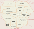
 Location in Rio Grande do Sul, Brazil | |
 Canoas Location in Brazil | |
| Coordinates: 29°55′12″S 51°10′48″W / 29.92000°S 51.18000°W | |
| Country | Brazil |
| Region | South |
| State | Rio Grande do Sul |
| Established | June 27, 1939 |
| Government | |
| • Mayor | Jairo Jorge |
| Area | |
| • Total | 131.097 km2 (50.6 sq mi) |
| Elevation | 8 m (26 ft) |
| Population (2020 [1]) | |
| • Total | 348,208 |
| • Density | 2,700/km2 (6,900/sq mi) |
| Time zone | UTC-3 (BRT) |
| • Summer (DST) | UTC-2 (BRST) |
| Website | canoas.rs.gov.br |


Canoas is an industrial and educational hub, drawing residents from surrounding municipalities. It hosts a campus of the Federal Institute of Rio Grande do Sul and several universities including Ulbra, UniRitter, Universidade La Salle, and IPUC. The city is positioned at an elevation of eight meters above sea level, and is distinguished by the Gravataí and Sinos rivers that traverse its landscape.
Etymology edit
The city's name, Canoas, which means canoes in Portuguese, traces back to the area's early settlement period during the construction of the railway line from Porto Alegre to São Leopoldo in 1874. A significant local event was the utilization of a large timbaúva tree (Enterolobium contortisiliquum) for constructing vessels on what was then the Gravataí Farm. This site became known as Capão das Canoas, influencing the names of the railway station and subsequent settlement. The timbaúva tree is also recognized as the city's symbolic tree.
History edit
The region that is now Canoas was originally inhabited by the Tapes Indigenous peoples until the arrival of Portuguese explorers and settlers in the early 18th century. Francisco Pinto Bandeira, a notable early settler, established the Gravataí Farm in the area by 1733. Over the following decades, the farm was subdivided and sold in smaller plots, leading to increased settlement.
The construction of the railway in 1871 to connect São Leopoldo and Porto Alegre marked a pivotal development for the area. The establishment of a railway station in 1874 catalyzed the growth of the settlement that would become Canoas. The use of local timber for canoe making at the station helped name the area Capão das Canoas.
Significant growth continued into the 20th century with the arrival of the Lasallian brothers in 1908, who founded a school that offered agricultural, primary, and secondary education. The military also played a crucial role in the city's development, particularly with the establishment of the 3rd Military Aviation Regiment in 1937, which was instrumental in advocating for the city's emancipation. Canoas officially became a city in 1939 and continued to expand rapidly, especially from the 1970s onwards, establishing itself as a key economic player in the state.
Pictures of Canoas edit
-
 Canoas subdivisions
 -
 Guajuviras neighbourhood
 -
 Canoas Air Base
 -
 Downtown Canoas
 -
 Getulio Vargas neighbourhood
 -
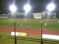 Soccer game at the Ulbra Sport Club in the São José neighbourhood
 -
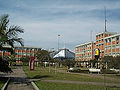 Ulbra University
 -
 ULBRA Technological Museum
 -
 Chapel at the ULBRA
 -
 La Salle University
 -
 Old rail line in the Industrial neighbourhood
 -
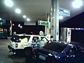 Gas station in the Igara neighbourhood
 -
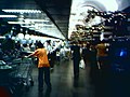 Zaffari Bourbon grocery store in the Getulio Vargas neighbourhood
 -
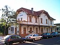 Cultural Foundation of Canoas in the historical train station building
 -
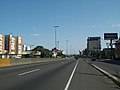 BR-116 Federal Highway in Canoas
 -
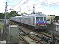 Urban Train that passes through Canoas
 -
 Canoas Intermunicipal Bus Station
 -
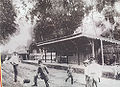 Canoas Train Station in 1874
 -
 Main Catholic Church, 1931
 -
 Typical vegetation in Canoas


See also edit
External links edit
- Canoas Mayoral Office (in Portuguese)
- Satellite view of Canoas
- Images of the city and its History (in Portuguese) Images of homes are not representative of the rest of the city - the homes shown are part of one wealthy subdivision in the city
- SOGAL - Sociedade de Ônibus Gaúcha: Canoas City's Bus Transport (in Portuguese)
- ULBRA - Lutheran University of Brazil (in Portuguese)
References edit
- ^ "IBGE 2020". Archived from the original on 2021-01-30. Retrieved 2021-01-22.