Bina (Azerbaijani: Binə; Armenian: Բինա) or Tumi (Armenian: Տումի) is a village in the Khojavend District of Azerbaijan, in the disputed region of Nagorno-Karabakh. The village had an ethnic Armenian-majority population prior to the 2020 Nagorno-Karabakh war, and also had an Armenian majority in 1989.[2]
Bina / Tumi
Binə / Տումի | |
|---|---|
 | |
 Bina / Tumi | |
| Coordinates: 39°34′59″N 46°54′05″E / 39.58306°N 46.90139°E | |
| Country | |
| District | Khojavend |
| Population (2015)[1] | |
| • Total | 746 |
| Time zone | UTC+4 (AZT) |
Toponymy edit
The village was known as Domi (Armenian: Դոմի; Russian: Домы; Azerbaijani: Domı) during the Soviet period.[3]
History edit

During the Soviet period, the village was a part of the Hadrut District of the Nagorno-Karabakh Autonomous Oblast.
The village was administered by the Republic of Artsakh as part of its Hadrut Province after the First Nagorno-Karabakh War. The village was captured in 9 November 2020 by Azerbaijani forces during the 2020 Nagorno-Karabakh war with the Armenian population of the village having previously evacuated.
Historical heritage sites edit
Historical heritage sites in and around the village include a cemetery from between the 9th and 19th centuries, the 11th-century Church of the Red Cross (Armenian: Եկեղեցի Կարմիր Խաչ, romanized: Yekeghetsi Karmir Khach), a 12th/13th-century khachkar, a 12th/13th-century bridge, the fortress of Ghlen Kar (Armenian: Ղլեն Քար, also known as Dizapayt Fortress and Gorozaberd, Գոռոզաբերդ) from between the 13th and 19th centuries, and a 19th-century spring monument.[1]
Demographics edit
The village had 760 inhabitants in 2005,[4] and 746 inhabitants in 2015.[1]
Gallery edit
-
 Igakuts Bridge
 -
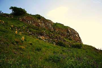 Ghlen Kar Fortress
 -
 Bridge near Tumi
 -
 Jrvanes Bridge


References edit
- ^ a b c Hakob Ghahramanyan. "Directory of socio-economic characteristics of NKR administrative-territorial units (2015)".
- ^ Андрей Зубов. "Андрей Зубов. Карабах: Мир и Война". drugoivzgliad.com.
- ^ Landmine Mapper. "Azerbaijan (& Nagorno Karabakh) Topographic Map 1:200,000 Russian Soviet Military". GigaPan.
- ^ "The Results of the 2005 Census of the Nagorno-Karabakh Republic" (PDF). National Statistic Service of the Republic of Artsakh. Archived from the original (PDF) on 2011-03-02. Retrieved 2009-02-26.
External links edit
This Khojavend District location article is a stub. You can help Wikipedia by expanding it. |