State Route 260, also known as SR 260, is a 217.78-mile (350.48 km) long east–west major state highway in the north-central part of the U.S. state of Arizona. It connects State Route 89A in Cottonwood to U.S. Route 180 and U.S. Route 191 in Eagar. The highway begins in Yavapai County before entering Coconino County and then entering Gila County before reentering Coconino County and then entering Navajo and Apache counties, where the highway ends.
State Route 260 | ||||
|---|---|---|---|---|
 SR 260 highlighted in red | ||||
| Route information | ||||
| Maintained by ADOT | ||||
| Length | 217.78 mi[2] (350.48 km) | |||
| Existed | 1970–present | |||
| Tourist routes | ||||
| Major junctions | ||||
| West end | ||||
| East end | ||||
| Location | ||||
| Country | United States | |||
| State | Arizona | |||
| Counties | Yavapai, Coconino, Gila, Navajo, Apache | |||
| Highway system | ||||
| ||||
| ||||

Route description edit
The western terminus of SR 260 is located at State Route 89A in Cottonwood and heads eastbound along much of the Mogollon Rim, finally ending at its junction with U.S. Route 180 and U.S. Route 191 in Eagar. SR 260 is part of the National Highway System between Show Low and Payson.
Stretches of this highway are known by various names, include Camp Verde Bridgeport Highway, General George Crook Trail, Zane Grey Highway, Camp Verde-Payson Highway, and White Mountain Road / Boulevard. The northernmost stretch between Cottonwood and Camp Verde was originally State Route 279, while the original stretch of road from Payson to Eagar was originally State Route 160.
SR 260 was scheduled in 1995, to be widened and upgraded between Payson and Heber-Overgaard to a four lane divided highway with bridges over wildlife corridors to reduce accidents with deer/elk and other wildlife. The road project has never been completed and is still two lanes over much of the route and is congested at times during holiday weekends with traffic from the Phoenix area to areas along the eastern Rim. Care must be observed due to narrow two lanes and wildlife crossing the road. It is also closed during winter storms because of its elevation changes between Payson and Show Low.
History edit
SR 260 was originally designated in 1955 as SR 160 from Payson to Show Low. In 1969, US 160 extended into Arizona so SR 160 was renumbered to SR 260 to avoid confusion. In 1972, it extended east to Eagar, replacing SR 173 and part of SR 73. On December 15, 1989, SR 260 extended west to Cottonwood over SR 279.
-
 Arizona State Highway 260 winding its way through the Tonto Forest just below the Mogollon Rim.
 -
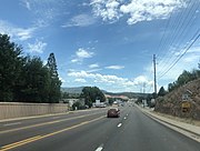 Star Valley is bisected by Highway 260


Junction list edit
| County | Location | mi[2] | km | Destinations | Notes |
|---|---|---|---|---|---|
| Yavapai | Cottonwood | 0.00 | 0.00 | Western terminus; former US 89A; road continues as Cove Parkway | |
| Camp Verde | 12.24 | 19.70 | I-17 exit 287 | ||
| Coconino | | 46.16 | 74.29 | West end of SR 87 concurrency | |
| Mogollon Rim | Coconino–Gila county line | ||||
| Gila | Payson | 71.62 | 115.26 | East end of SR 87 concurrency | |
| Mogollon Rim | Gila–Coconino county line | ||||
| Coconino | | 103.18 | 166.05 | Desert to Tall Pines Scenic Road (Young Road) | To SR 288 |
| Navajo | Heber-Overgaard | 124.62 | 200.56 | ||
| Show Low | 159.03 | 255.93 | West end of US 60/SR 77 concurrency | ||
| 161.00 | 259.10 | East end of US 60/SR 77 concurrency; serves Show Low Regional Airport | |||
| Indian Pine | 176.74 | 284.44 | |||
| Apache | | 187.88 | 302.36 | ||
| | 196.73 | 316.61 | |||
| | 204.89 | 329.74 | |||
| Eagar | 212.34 | 341.73 | SR 261 closed winters | ||
| 217.78 | 350.48 | Eastern terminus | |||
1.000 mi = 1.609 km; 1.000 km = 0.621 mi
| |||||
References edit
- ^ Arizona Department of Transportation (2014). "Arizona Parkways, Historic and Scenic Roads" (PDF). Phoenix: Arizona Department of Transportation. Archived from the original (PDF) on September 11, 2018. Retrieved September 11, 2018.
- ^ a b Arizona Department of Transportation. "2008 ADOT Highway Log" (PDF). Archived from the original (PDF) on December 28, 2010. Retrieved April 8, 2008.