Alameda is a town in south-eastern Saskatchewan, Canada, approximately 50 km east of Estevan. A translation of Alameda from Spanish is "Poplar Grove" or "Tree Lined Avenue". One popular story is that the town was named for Alameda, California although there is no written documentation to support this.[4] Alameda had a population of 369 in the Canada Census of 2016.
Alameda | |
|---|---|
Town | |
 Alameda, Sk | |
 Alameda Location of Alameda in Saskatchewan  Alameda Alameda (Canada) | |
| Coordinates: 49°16′N 102°17′W / 49.26°N 102.28°W | |
| Country | Canada |
| Province | Saskatchewan |
| Census division | 1 |
| Rural Municipality | Moose Creek |
| Post office Founded | 1883 |
| Government | |
| • Mayor | Perry Kinder |
| • Town Manager | Michelle Needham |
| • Governing body | Alameda Town Council |
| Area | |
| • Total | 2.55 km2 (0.98 sq mi) |
| Population (2016) | |
| • Total | 369 |
| • Density | 144.5/km2 (374/sq mi) |
| Time zone | CST |
| Postal code | S0C 0A0 |
| Area code | 306 |
| Highways | Hwy 361 |
| Climate | Dfb |
| Website | Official website |
| [1][2][3] | |
Alameda is situated in the south-east corner of Saskatchewan. The closest larger centres to Alameda are Estevan, Weyburn, Regina, and Minot, North Dakota. Alameda sits in an area that is abundant with grain, oil, and water.
Demographics edit
In the 2021 Census of Population conducted by Statistics Canada, Alameda had a population of 345 living in 162 of its 187 total private dwellings, a change of -6.5% from its 2016 population of 369. With a land area of 2.53 km2 (0.98 sq mi), it had a population density of 136.4/km2 (353.2/sq mi) in 2021.[5]
| 2021 | 2011 | |
|---|---|---|
| Population | 345 (-6.5% from 2016) | 342 (+11.0% from 2006) |
| Land area | 2.53 km2 (0.98 sq mi) | 2.55 km2 (0.98 sq mi) |
| Population density | 136.6/km2 (354/sq mi) | 133.9/km2 (347/sq mi) |
| Median age | 40.0 (M: 38.0, F: 43.2) | 44.2 (M: 39.0, F: 46.7) |
| Private dwellings | 187 (total) 162 (occupied) | 162 (total) |
| Median household income | $88,000 |
Amenities edit
Alameda offers the following community facilities: a community ice rink (skating, curling), Heritage museum, and the Alameda Merry Makers Senior Centre.
Alameda offered a wide range of services for its residents, which included a full-service grocery and meat store, a restaurant, a banking institution, full-service campground as well as many others. As with other small communities in Saskatchewan, many of the businesses are closing and/or closed and the residents drive to other communities for services that once were in their community.
Alameda is famous for being the home of the Grant Devine Dam (formerly the Alameda Dam) which has turned into a full-service recreational area. The Grant Devine Dam is the home of the Alameda Fishing Derby which takes place the 3rd weekend of June each year. It is also the home of Moose Creek Regional Park and 9-hole golf course.
Alameda hosts various events throughout the year including the Alameda Agricultural Society fair and 4-H show and sale and the Alameda Flower Show.
Gallery edit
-
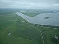 Grant Devine Reservoir & Dam
 -
 Views of Alameda 1909
 -
 Fifth Street in 1908
.jpg)
.jpg)

Notable people edit
- George Ramsay Cook – OC, FRSC, Canadian historian and general editor of the Dictionary of Canadian Biography.
- John James Harrop – Politician
- Trent Whitfield, drafted 100th overall in the 1996 NHL Draft by the Boston Bruins currently plays for HC Bolzano in the Austrian Hockey League (EBEL), is from Alameda.
See also edit
References edit
- ^ National Archives, Archivia Net. "Post Offices and Postmasters". Archived from the original on 6 October 2006. Retrieved 26 April 2014.
- ^ Government of Saskatchewan, MRD Home. "Municipal Directory System". Archived from the original on 15 January 2016. Retrieved 26 April 2014.
- ^ Commissioner of Canada Elections, Chief Electoral Officer of Canada (2005). "Elections Canada On-line". Archived from the original on 21 April 2007. Retrieved 26 April 2014.
- ^ Rayburn, Alan (2001). Naming Canada: Stories about Canadian Place Names. University of Toronto Press. p. 117. ISBN 9780802047250.
- ^ "Population and dwelling counts: Canada, provinces and territories, census divisions and census subdivisions (municipalities), Saskatchewan". Statistics Canada. 9 February 2022. Retrieved 1 April 2022.
- ^ "2021 Community Profiles". 2021 Canadian Census. Statistics Canada. 4 February 2022. Retrieved 19 October 2023.
- ^ "2011 Community Profiles". 2011 Canadian Census. Statistics Canada. 21 March 2019. Retrieved 26 April 2014.
- ^ "2006 Community Profiles". 2006 Canadian Census. Statistics Canada. 20 August 2019.
- ^ "2001 Community Profiles". 2001 Canadian Census. Statistics Canada. 18 July 2021.