Ainhoa (French pronunciation: [ajnɔa]; Basque: Ainhoa) is a commune in the Pyrénées-Atlantiques department in the Nouvelle-Aquitaine region in southwestern France.
Ainhoa | |
|---|---|
 The town square in Ainhoa | |
.svg) Coat of arms | |
Location of Ainhoa  | |
 Ainhoa  Ainhoa | |
| Coordinates: 43°18′26″N 1°29′51″W / 43.3072°N 1.4975°W | |
| Country | France |
| Region | Nouvelle-Aquitaine |
| Department | Pyrénées-Atlantiques |
| Arrondissement | Bayonne |
| Canton | Ustaritz-Vallées de Nive et Nivelle |
| Intercommunality | Pays Basque |
| Government | |
| • Mayor (2020–2026) | Michel Ibarlucia[1] |
| Area 1 | 16.19 km2 (6.25 sq mi) |
| Population (2021)[2] | 667 |
| • Density | 41/km2 (110/sq mi) |
| Time zone | UTC+01:00 (CET) |
| • Summer (DST) | UTC+02:00 (CEST) |
| INSEE/Postal code | 64014 /64250 |
| Elevation | 52–649 m (171–2,129 ft) (avg. 120 m or 390 ft) |
| 1 French Land Register data, which excludes lakes, ponds, glaciers > 1 km2 (0.386 sq mi or 247 acres) and river estuaries. | |


Geography edit
Location edit
The commune of Ainhoa is in the traditional Basque province of Labourd.
Ainhoa is some 20 km due south of Bayonne and is directly on the Spanish border which forms the southern border of the commune. The commune is mountainous and forested in the south-east portion but with farmland in the northwest of the commune. There is one border crossing to Spain on the southern border at the village of Dantxana.
Ainhoa and Sare, together with the two Spanish communes of Zugarramurdi and Urdazubi, form a cross-border territory, called Xareta. Straddling the border with Spain, it is a passage for the Way of St. James (Baztan way) from Bayonne to Pamplona.
The commune's border with Spain is in the Dancharia area and accesses the area of Dantxarinea d'Urdazubi.
Access edit
The commune is connected to Espelette in the north-east by Highway D20 which passes through the village and continues south to the Spanish border. Highway D305 branches west off the D20 and continues west to join Highway D4 before Cherchebruit. A network of small country roads covers all parts of the commune.[3]
Hydrography edit
Located in the watershed of the Adour, the Nivelle river runs along the southern border and forms the border between France and Spain. Numerous streams arise in the commune and flow down to the Nivelle including the Opalazioko erreka, the Lapitxuri and its tributaries, the Larreko erreka, the Erdiko erreka, the Farendeiko erreka, the Haitzagerriko erreka, and the Barretako erreka. Paul Raymond mentions[4] the Haïçaguerry, a tributary of the Nivelle, which descended to Gorospila on the Spanish border, and which crossed the territory of Ainhoue (the old spelling of Ainhoa).
Localities and hamlets edit
- Agerrea
- Akatenea
- Arbonakoborda
- Armaia
- Armaiaetxeberria
- Arotxenborda
- Barnetxekoborda
- Capera[4]
- Chapelle d'Arantze
- Col de Gorospil
- Dantxaria[4]
- Dolharekoborda
- Esponda
- Ezpondakoborda
- Fulianborda
- Gaskoinenborda
- Haizagerri[4]
- Haltienborda
- Hariztoienborda
- Harotxarenborda
- Janmarienborda
- Joaniorenborda
- Kanpainia
- Kontxoenea
- Mazondoa
- Mendiondoa
- Mentaberria
- Murruenea
- Narkoinborda
- Okilaua
- Olhatxoa
- Ordokikoborda
- Ordosgoitikoborda
- Patzikoenborda
- Peorteikoborda
- Perlaenborda
- Tanburinborda
- Ukutea
- Urrutieneko Errota
- Xara Handia
- Xarak
Toponymy edit
The commune name in basque is the same - Ainhoa.
Brigitte Jobbé-Duval[6] suggested that the name could come from the Basque aino which means "goat".
The following table details the origins of the commune name and other names in the commune.
| Name | Spelling | Date | Source | Page | Origin | Description |
|---|---|---|---|---|---|---|
| Ainhoa | Aynoa | 1238 | Orpustan | Village | ||
| Aynho | 1243 | Orpustan | ||||
| Aignoa | 1249 | Orpustan | ||||
| Aynoa | 1249 | Orpustan | ||||
| Haynou | 1289 | Orpustan | ||||
| Anhoe | 1289 | Orpustan | ||||
| Nostre-Done d'Ainhoe | 1511 | Raymond | 4 |
Saint-Claire | ||
| Añoa | 1650 | Map | ||||
| Anhoue | 1684 | Raymond | 4 |
Collations | ||
| Ainhoüé | 1750 | Cassini | ||||
| Mendiate | 18th century | Ldh/EHESS/Cassini | ||||
| Mendiarte | 1793 | Raymond | 4 |
|||
| Ainhone | 1793 | Ldh/EHESS/Cassini | ||||
| Ainhoue | 1801 | Ldh/EHESS/Cassini | Bulletin des Lois | |||
| Ainhoa | 1801 | Ldh/EHESS/Cassini | Bulletin des Lois | |||
| Ainhoue | 1863 | Raymond | 4 |
|||
| Ainhoa | 19th century | Lhande | ||||
| Capéra | Capéra | 1863 | Raymond | 41 |
Chapel | |
| Dantxaria | Dancharia | 1863 | Raymond | 54 |
Hamlet | |
| Landibar | Landibar | 1863 | Raymond | 91 |
Bridge on the Haïçaguerry |
Sources:
- Orpustan: Jean-Baptiste Orpustan, New Basque Toponymy[7]
- Raymond: Topographic Dictionary of the Department of Basses-Pyrenees, 1863, on the page numbers indicated in the table. (in French)[4]
- Map: The Map of the Government-General of Guyenne and Gascony and the neighbouring region
- Cassini: Cassini Map from 1750[8]
- Ldh/EHESS/Cassini: Des villages de Cassini aux communes d'aujourd'hui: Commune data sheet Ainhoa, EHESS (in French).
- Lhande: Pierre Lhande, Basque-French Dictionary[9]
Origins:
- Saint-Claire: Titles of the Abbey of Sainte-Claire of Bayonne[10]
- Collations: Collations of the Diocese of Bayonne[11]
History edit
The ancient redoubt of Urrizti reflects the ancient past of the area.
From the 13th to 17th Centuries edit
Paul Raymond noted on page 4 of his 1863 dictionary that the parish of Ainhoa was in the gift of the Abbot of Urdax (Spain).[4] The Curacy of Ainhoa was created by the Priory of the Premonstratensian of Urdazubi in the 13th century.
On 27 April 1238 the new king Theobald I of Navarre purchased the toll rights formerly instituted by Viscount Juan Pérez de Baztan, Ainhoa being then at the borders between the Duchy of Aquitaine since 1151, run by the Angevin Kings of England and the Navarrese kingdom.
Such tolls were charged to pilgrims and traders traveling to Santiago de Compostela on the Way of St. James in Galicia, Spain. Military clashes between the "English run" Basques of Aquitaine and the Navarrese in 1249 led the Seigneur of Ainhoa, in 1250, to recognize the suzerainty of King Henry III of England. By 1265 Gonzalvo Juanis, Seigneur of Ainhoa, also known as Gonzalvo Ibáñez or Gonzalvo Yáñes, did not recognize either the English or the Navarrese. However he died in 1289 and opened the way to conquest based on old historical claims. Then, Garda Arnaut de Espelette, with loyalty to the "English run" Basques of the Duchy of Aquitaine, sent a letter, dated 29 July 1289 praying the Ainhoa people to adequately connive with him. The outcome of such frontier business was to set up an "undivided" land as had been done also previously with the nearby Aldudes close to the Baztan valley.
Documents from Estella dated September 1369, some 80 years later, proved that the people from Ainhoa paid taxes to both the King of Navarre and the "English" Seneschal of the Landes territory in return for their fiscal and personal privileges.
When "English run" Bayonne surrendered to the French in 1451 it is not known if these "undivided status" villages on the English-Navarrese frontier were taken by the French as well.
In the Spanish Invasion of 1636 in the Labourd territories many villages, including Ainhoa, were razed. Later, probably because of the 1659 "Treaty of the Pyrénées" whereby the Spanish-born Queen regent of France Anne of Austria with the help of Cardinal Mazarin, the First Minister of France, set up an advantageous (for the French) peace and also obtained Maria Theresa of Spain as a wife for her son Louis XIV of France. Ainhoa was then repopulated again.
Disputes between the new settlers and the old residents concerning the use of communal lands for cattle grazing and fodder and the access by newcomers to town hall positions, schooling, church grants, etc. had to be settled by the then autonomous Parliament of Bordeaux in the sense of paying for access to village privileges.
Ainhoa was destroyed during the Thirty Years War (1618-1648) and then rebuilt. The only remains from before the destruction are the church and the Machitorénéa House.
The 18th century edit
In 1724, following the revolts in Saint-Jean-le-Vieux (1685) Mouguerre and Saint-Pierre-d'Irube (1696), the people of Ainhoa revolted against the salt tax and against other new taxes. This was a prelude to the uprisings in all of Labourd in 1726 against the said taxes. Bayonne and Saint-Jean-Pied-de-Port followed in 1748.[12]
The Law of 4 March 1790[13] determined a new administrative landscape of France by creating departments and districts. This resulted in the creation of the department of Basses-Pyrénées and reuniting the Béarn, the Gascon lands of Bayonne and Bidache, and the three French Basque provinces. For the latter, three districts were created: Mauleon, Saint-Palais, and Ustaritz which replaced the Bailiwick of Labourd. The seat of Ustaritz was transferred almost immediately to Bayonne. Its Director persuaded a large number of municipalities to adopt new names conforming to the spirit of the Revolution. So Ainhoa was called Mendiarte, Ustaritz became Marat-sur-Nive, Itxassou became Union, Arbonne became Constante, Saint-Étienne-de-Baïgorry became Thermopyles, Saint-Palais became Mont-Bidouze, Louhossoa became Montagne-sur-Nive, Saint-Jean-Pied-de-Port became Nive-Franche, Saint-Jean-de-Luz became Chauvin-Dragon (the name of a young soldier killed in action), and Souraïde became Mendialde.
In 1794, at the height of the Terror and after the desertion of forty seven young people from Itxassou, the Committee of Public Safety (Decree of 13 Ventôse Year II - 3 March 1794) arrested and deported some of the inhabitants (men, women and children) of Ainhoa, Ascain, Espelette, Itxassou, Sare, and Souraïde and decreed that these communes like the other communes of the Spanish border were "infamous communes".[14] This was extended to Biriatou, Cambo-les-Bains, Larressore, Louhossoa, Mendionde, and Macaye.
The people were "united in various national houses, or in the district of Ustaritz or in the Great Redoubt, like Jean-Jacques Rousseau".[15] In reality, they were gathered together in churches and then deported in very precarious conditions[16] in Bayonne, Capbreton, Saint-Vincent-de-Tyrosse, and Ondres. The Departments where people from the communes were interned were the Lot, the Lot-et-Garonne, the Gers, the Landes, the Basses-Pyrenees (partly béarnaise), and Hautes-Pyrenees.
The return of exiles and the recovery of their possessions were determined by a series of decrees issued on 29 September and 1 October 1794, driven in this direction by the Director of Ustaritz who said: "The onetime communes of Sare, Itxassou, Ascain, Biriatou, and Serres, whose inhabitants were interned eight months ago as a measure of general safety, have not been improved. The people who come to obtain freedom to retire to their homes, clamour for food without my being able to procure the means to meet this primary human need, hunger.".[17] The recovery of their possessions was not without difficulty, they were placed in receivership but were not registered and were looted: "The property, movable and immovable, of the inhabitants of Sare, were neither recorded nor legally described, and all our furniture and household effects were removed and brought confusedly to neighbouring communes. Instead of being put in safe places, some were sold at auction and sometimes sold without auction.".[18]
19th-20th Centuries edit
During the retreat of the Napoleonic Army from Spain in 1813, Labourd villages were again submitted to abuse by the Confederate British and Spanish troops.
Under the German occupation of France during World War II many of these frontier villages were fully administered by the German military, but were also an escape route for British soldiers, French Resistance members, and European Jews trying to reach non-belligerent Spain.
Heraldry edit
| |
Blazon: Or, fess bar in gules, in chief a saltorel of azure, in base a sabre gules in fesse pointed sinister surmounted by a crescent vert.[19]
|
Administration edit
List of Successive Mayors of Ainhoa[20]
| From | To | Name |
|---|---|---|
| 1995 | 2001 | Bernard Saint-Jean |
| 2001 | 2008 | Philippe Aspirot |
| 2008 | 2010 | Henri Daguerre |
| 2010 | 2026 | Michel Ibarlucia |
Intercommunality edit
Ainhoa is one of seven intercommunal organisations:
- the Communauté d'agglomération du Pays Basque
- the SIVU Errebi
- the SIVU for the implementation of Natura 2000 on the Mondarrain and Artzamendi mountain ranges
- the AEP Nive-Nivelle Union
- the "Bizi Garbia" mixed union
- the union to support Basque culture
- the energy union of Pyrénées-Atlantiques
Population edit
| Year | Pop. | ±% p.a. |
|---|---|---|
| 1968 | 579 | — |
| 1975 | 543 | −0.91% |
| 1982 | 544 | +0.03% |
| 1990 | 539 | −0.12% |
| 1999 | 599 | +1.18% |
| 2007 | 658 | +1.18% |
| 2012 | 669 | +0.33% |
| 2017 | 672 | +0.09% |
| Source: INSEE[21] | ||
The commune is part of the urban area of Bayonne. The inhabitants of the commune are known as Ainhoars in French.[22]
Economy edit
Iron ore was mined until the 19th century.[23] Its initial operation was by the Premonstratensian of Saint-Sauveur of Urdax.[24]
The weaving of flax (tisserands) and wool (duranguiers) persists in Ainhoa where in Hasparren it was an important activity until the advent of the textile industry in the 19th century.[25]
Philippe Veyrin[26] noted the existence of a factory making "chahako", small goatskins from male goats which peasants use for work or hunting. Ainhoa is part of the Appellation zone (AOC) for the production of pimentos of Espelette and also the AOC of the Ossau-iraty. The activities in the commune are mainly agricultural and forestry (500 hectares of forest over an area of 1619 hectares). A quarry is always operating in the municipality.
Culture and heritage edit
The town has received an award from the Most beautiful villages in France, an award from an independent organization to promote the tourist attractions of small communes rich with quality heritage.
Languages edit
According to the Map of the Seven Basque Provinces by Prince Louis-Lucien Bonaparte published in 1863, the dialect of Basque spoken in Ainhoa is labourdin.
Civil heritage edit
The village is laid out as a fortified town, with concealed labourdine houses from the 17th century and a fronton open square against the cemetery surrounding the church.
- The Alhaxurruta Fountain well is present between the village and the Dancharia area and was noticed by Napoleon III and Eugénie de Montijo during a tour here on 23 September 1858.
 |
 |
 |
Religious Heritage edit
- The Church of Our Lady of the Assumption (13th century)
 is registered as an historical monument.[27]
 - The Chapel of Notre-Dame-d'Aubépine (Mary appeared to a young shepherd in a hawthorn bush (or arantza in Basque) hence the other name of the chapel Our Lady of Aranzazu) has had a Way of the Cross since 1886, a grotto since 1897, and a Calvary since 1898.[28] In the 18th century, the parish of Ainhoa subsidized the hermit of the chapel to teach reading and writing to the shepherds and children in nearby farms who could not easily access the town.[29]
The cemetery contains Hilarri from the 16th and 17th centuries.
-
 The Church of Our Lady of the Assumption
 -
 Stained glass in the church
 -
 The cemetery
 -
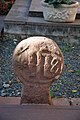 Discoidal Stele
 -
 Tabular Stele
 -
 Discoidal Stele
 -
 Church and cemetery
 -
 Cemetery
 -
 Headstone
 -
 Headstone
 -
 The Calvary dating to 1898
 -
 Rectangular Cross


Environmental heritage edit
Ainhoa Forest stretches over 400 hectares and is home to a rich fauna of both wild animals (deer, wild boar, hares, and migratory birds) and semi-wild pastoral animals (pottoks, "bestisos", and goats). The forest consists mainly of oak trees, rustic essence and newer vegetation such as red American oak and softwood).
Facilities edit
Sports Facilities edit
Pelota is played in the Fronton in the village and the covered fronton at Ur Hegian.
Education edit
The town has a public primary school.
Health edit
Two GPs are present in the town.
Notable People linked to the commune edit
- Jean-Pierre Duvoisin, born in 1810 at Ainhoa and died in 1891 at Ciboure was a Basque writer.
See also edit
Notes edit
References edit
- ^ "Répertoire national des élus: les maires". data.gouv.fr, Plateforme ouverte des données publiques françaises (in French). 2 December 2020.
- ^ "Populations légales 2021". The National Institute of Statistics and Economic Studies. 28 December 2023.
- ^ Google Maps
- ^ a b c d e f Topographic Dictionary of the Department of Basses-Pyrenees, Paul Raymond, Imprimerie nationale, 1863, Digitised from Lyon Public Library 15 June 2011 (in French)
- ^ Géoportail, IGN (in French)
- ^ Brigitte Jobbé-Duval, Dictionary of Place Names - Pyrénées-Atlantiques, 2009, Archives and Culture, ISBN 978-2-35077-151-9
- ^ Jean-Baptiste Orpustan, New Basque Toponymy, Presses universitaires de Bordeaux, 2006, ISBN 2 86781 396 4 (in French)
- ^ Cassini Map 1750 – Ainhoüé
- ^ Pierre Lhande, Dictionnaire basque-français, 1926
- ^ Titles of the Abbey of Sainte-Claire of Bayonne - Departmental Archives of Pyrénées-Atlantiques (in French)
- ^ Manuscripts from the 17th and 18th centuries in the Departmental Archives of Pyrénées-Atlantiques (in French)
- ^ Philippe Veyrin, The Basques, Arthaud, 1975, ISBN 2700300386, page 179. (in French)
- ^ Philippe Veyrin, The Basques, Arthaud, 1947, Re-ed. 1975, ISBN 2700300386, page 185. (in French)
- ^ Philippe Veyrin, The Basques, Ed. Arthaud, 1975, ISBN 2700300386, page 187. (in French)
- ^ National Archives, AF II 133/1014, cited by Manex Goyhenetche, General History of Basque Country - Vol 4, Elkarlanean, 2002, ISBN 2913156460, page 300 (in French)
- ^ The Mayor and the Municipal officer of Capbreton
requested instructions from the representatives of the people by a letter (text transcribed by P. Haristoy, The Parishes of the Basque Country during the revolutionary period, Pau, Vignancour, 1895-1901, pages 256-257) of 24 Ventôse Year II (14 March 1794) for the 229 prisoners in their charge:
- How much bread to give to every man (we do not have bread, so it does not matter)?
- Can we consent for them to buy wine or other provisions?
- We note that we have no meat.
- Can we allow them to have light at night from a lantern?
- Can we allow them to have their mattresses or palliasses? We have let them bring straw to sleep
- Can we allow them out two by two to wash their clothes
- If there are sick, are we allowed to take them out of the prison house to show the others that they are to be treated?"
- ^ National Archives, F11/394, 18 vendémiaire Year III (9 October 1794), cited by Manex Goyhenetche, General History of Basque Country - Vol 4, Elkarlanean, 2002, ISBN 2913156460, page 309
- ^ Bulletin of the Society of Sciences, Letters and Arts of Bayonne, 1935, pages 67 to 70, and The Parishes of Basque Country, page 263, Gure Herria, 1930-1932 - Sources cited by Manex Goyhenetche, General History of Basque Country - Vol 4, Elkarlanean, 2002, ISBN 2913156460, page 310 (in French)
- ^ Guy Ascarat Archived November 9, 2013, at the Wayback Machine
- ^ List of Mayors of France (in French)
- ^ Population en historique depuis 1968, INSEE
- ^ Pyrénées-Atlantiques, habitants.fr
- ^ Philippe Veyrin, The Basques, Arthaud, 1975, ISBN 2700300386, page 22 (in French)
- ^ Philippe Veyrin, The Basques, Arthaud, 1975, ISBN 2700300386, page 109 (in French)
- ^ Philippe Veyrin, The Basques, Arthaud, 1975, ISBN 2700300386, page 42 (in French)
- ^ Philippe Veyrin, The Basques, Arthaud, 1975, ISBN 2700300386, page 299
- ^ Ministry of Culture, Mérimée PA00132934 Church of Our Lady of the Assumption (in French)

- ^ Marie-France Chauvirey, The old life in Basque Country, Éditions Sud Ouest - Luçon, 1994, ISBN 2879012198, page 51. (in French)
- ^ Philippe Veyrin, The Basques, Arthaud, 1975, ISBN 2700300386, page 172. (in French)
External links edit
- Ainhoa official website Archived 2011-05-14 at the Wayback Machine (in French)
- AINHOA in the Bernardo Estornés Lasa - Auñamendi Encyclopedia (Euskomedia Fundazioa) (in Spanish)
- Ainhoüé on the 1750 Cassini Map
- Iparralde: the 6 best towns in French Basque Country (in English)