Acaster Selby is a village in the former Selby District of North Yorkshire, England. It is part of the joint civil parish with Appleton Roebuck (where the population is now included). It is situated about 6 miles (9.7 km) south from York, on the west back of the River Ouse; near the opposite bank is the settlement of Stillingfleet, and 1.3 miles (2.1 km) to the north-west is Appleton Roebuck.
| Acaster Selby | |
|---|---|
 College Farm, Acaster Selby | |
.svg) Acaster Selby Location within North Yorkshire | |
| Population | 56 (2001) |
| OS grid reference | SE573414 |
| • London | 165 mi (266 km) S |
| Unitary authority | |
| Ceremonial county | |
| Region | |
| Country | England |
| Sovereign state | United Kingdom |
| Post town | YORK |
| Postcode district | YO23 |
| Police | North Yorkshire |
| Fire | North Yorkshire |
| Ambulance | Yorkshire |
| UK Parliament | |
History edit
The name is derived from the Latin word for a camp, 'castra', indicating that the Roman army may once have been based near here. There is no longer any signs of such an encampment which was thought to have provided protection of the waterway to Tadcaster. The use of Selby indicates that the lands were brought within the control of Selby Abbey. This was done by Osbert de Arches at the time of the Norman Conquest and confirmed in the reign of Richard I.[1]
The village is listed in the Domesday Book as Acastre in the wapentake of Ainsty in the West Riding of Yorkshire, having 11 households under the lordship of Wulstan, who was replaced by Robert Malet in 1086.[2]
College Farm at Acaster Selby is named after a former college, or a chantry, which was dissolved during the reign of Henry VIII.[1] The site of the St Andrew's College, 1,440 feet (440 m) to the north-east of the farm, is a scheduled monument and includes extensive earthworks of buildings and a moated enclosure.[3]
Geography edit
The village has an area of 1,523 acres (6.2 km2).[1] It lies 1.3 miles (2.1 km) south-east of Appleton Roebuck.
Demography edit
According to the 1881 census the population was 115.[1] The 2001 census showed a population of 56 in 20 households.[4]
Governance edit
The Parish is part of joint parish with Appleton Roebuck and has one seat on its council.[5] It is part of the Selby & Ainsty constituency. It is part of the Appleton Roebuck and Church Fenton electoral division of North Yorkshire Council.[6]
Religion edit
St John's Church, Acaster Selby dates from 1850. It lies to the south of the village just off Back Lane.[1] It is a Grade II Listed Building.[7]
See also edit
Gallery edit
-
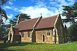 St John The Evangelist Church, Acaster Selby
 -
 River Ouse, Acaster Selby


References edit
- ^ a b c d e Bulmer's Topography, History and Directory (Private and Commercial) of North Yorkshire 1890. S&N Publishing. 1890. p. 854. ISBN 1-86150-299-0.
- ^ "Domesday Record". Archived from the original on 26 May 2013. Retrieved 13 October 2012.
- ^ Historic England. "St Andrew's College and moat, 440m north east of College Farm (1017457)". National Heritage List for England. Retrieved 25 January 2018.
- ^ "Census 2001". Archived from the original on 28 September 2011. Retrieved 13 October 2012.
- ^ "Parish Council". Archived from the original on 14 June 2011. Retrieved 13 October 2012.
- ^ "Divisions North Yorkshire Council". hub.arcgis.com. Retrieved 14 October 2023.
- ^ Historic England. "Church of St John (1316323)". National Heritage List for England. Retrieved 25 January 2018.
External links edit
 Media related to Acaster Selby at Wikimedia Commons
- Acaster [Selby] in the Domesday Book