Ústí nad Orlicí (Czech pronunciation: [ˈuːsciː ˈnat orlɪtsiː]; German: Wildenschwert) is a town in the Pardubice Region of the Czech Republic. It has about 14,000 inhabitants. The historic town centre is well preserved and is protected by law as an urban monument zone.
Ústí nad Orlicí | |
|---|---|
 Mírové Square | |
 Flag  Coat of arms | |
 Ústí nad Orlicí Location in the Czech Republic | |
| Coordinates: 49°58′26″N 16°23′37″E / 49.97389°N 16.39361°E | |
| Country | |
| Region | Pardubice |
| District | Ústí nad Orlicí |
| First mentioned | 1285 |
| Government | |
| • Mayor | Petr Hájek |
| Area | |
| • Total | 36.37 km2 (14.04 sq mi) |
| Elevation | 340 m (1,120 ft) |
| Population (2023-01-01)[1] | |
| • Total | 14,141 |
| • Density | 390/km2 (1,000/sq mi) |
| Time zone | UTC+1 (CET) |
| • Summer (DST) | UTC+2 (CEST) |
| Postal codes | 562 01, 562 03, 562 04, 562 06 |
| Website | www |
Administrative parts edit
.JPG)
Town parts of Hylváty, Kerhartice and Knapovec and villages of Černovír, Dolní Houžovec, Horní Houžovec and Oldřichovice are administrative parts of Ústí nad Orlicí.
Etymology edit
The name Ústí means literally "mouth (of the river)". It refers to its location at the confluence of rivers. The German name Wildenschwert was created by a distortion of the original German name Wilhelmswerd, which referred to one of colonizers on the area, Wilhelm von Dürnholz, and meant "Wilhelm's promontory".[2]
Geography edit
Ústí nad Orlicí is located about 44 kilometres (27 mi) east of Pardubice. It lies in the Svitavy Uplands. The highest point is the Strážný hill at 584 m (1,916 ft) above sea level. The town is situated at the confluence of the Tichá Orlice and Třebovka rivers.
Climate edit
| Climate data for Ústí nad Orlicí (1991–2020) | |||||||||||||
|---|---|---|---|---|---|---|---|---|---|---|---|---|---|
| Month | Jan | Feb | Mar | Apr | May | Jun | Jul | Aug | Sep | Oct | Nov | Dec | Year |
| Record high °C (°F) | 15.3 (59.5) |
16.0 (60.8) |
21.8 (71.2) |
28.3 (82.9) |
32.7 (90.9) |
35.1 (95.2) |
36.6 (97.9) |
37.4 (99.3) |
32.5 (90.5) |
24.7 (76.5) |
18.7 (65.7) |
13.5 (56.3) |
37.4 (99.3) |
| Mean daily maximum °C (°F) | 1.0 (33.8) |
2.9 (37.2) |
7.4 (45.3) |
14.1 (57.4) |
19.0 (66.2) |
22.3 (72.1) |
24.5 (76.1) |
24.6 (76.3) |
18.9 (66.0) |
12.6 (54.7) |
6.5 (43.7) |
1.9 (35.4) |
13.0 (55.4) |
| Daily mean °C (°F) | −1.7 (28.9) |
−0.6 (30.9) |
3.1 (37.6) |
8.5 (47.3) |
13.1 (55.6) |
16.4 (61.5) |
18.1 (64.6) |
17.7 (63.9) |
12.8 (55.0) |
8.2 (46.8) |
3.7 (38.7) |
−0.6 (30.9) |
8.2 (46.8) |
| Mean daily minimum °C (°F) | −4.4 (24.1) |
−3.7 (25.3) |
−0.8 (30.6) |
3.0 (37.4) |
7.4 (45.3) |
10.9 (51.6) |
12.5 (54.5) |
12.2 (54.0) |
8.4 (47.1) |
4.8 (40.6) |
1.2 (34.2) |
−2.9 (26.8) |
4.1 (39.4) |
| Record low °C (°F) | −24.5 (−12.1) |
−22.7 (−8.9) |
−18.0 (−0.4) |
−9.6 (14.7) |
−2.3 (27.9) |
0.9 (33.6) |
1.7 (35.1) |
4.1 (39.4) |
−2.6 (27.3) |
−7.7 (18.1) |
−13.5 (7.7) |
−24.6 (−12.3) |
−24.6 (−12.3) |
| Average precipitation mm (inches) | 54.3 (2.14) |
43.2 (1.70) |
48.9 (1.93) |
38.9 (1.53) |
70.9 (2.79) |
85.6 (3.37) |
103.4 (4.07) |
75.3 (2.96) |
62.1 (2.44) |
47.8 (1.88) |
50.1 (1.97) |
56.3 (2.22) |
736.6 (29.00) |
| Average precipitation days (≥ 1.0 mm) | 11.0 | 8.7 | 10.2 | 7.4 | 9.8 | 10.4 | 11.1 | 8.7 | 8.4 | 8.7 | 9.3 | 11.0 | 114.8 |
| Mean monthly sunshine hours | 50.3 | 76.5 | 124.5 | 190.5 | 224.1 | 228.6 | 237.7 | 236.3 | 165.6 | 105.8 | 46.1 | 37.3 | 1,723.4 |
| Source: NOAA[3] | |||||||||||||
History edit
Ústí nad Orlicí was founded in the second half of the 13th century, during the reign of King Ottokar II of Bohemia. Its predecessor was a Slavic settlement called Oustí.[4] The first written mention of the town is from 1285, when King Wenceslaus II gifted it to Záviš of Falkenstein.[2]
In 1292, after Zavis' death, Wenceslaus II gifted the settlement to the Cistercian monks at Königsaal. They passed the town to the Litomyšl bishopric in 1358. During the 15th and 16th centuries, it was owned by various noble families, including the Kostkas of Postupice or the Pernštejn family.[2]
The town was damaged by a large fire in 1495. After the Battle of White Mountain in 1620, Ústí was acquired by the Liechtenstein family. There were guilds of weavers established here in the 16th century. The town was slow to recover from the lootings of the Thirty Years' War, then was destroyed by fire in 1705.[2]
It gained municipal status in 1795. When Ústí was connected to the railway network by the Olomouc–Prague line in 1845, the textile business boomed. It gained the tagline of The Manchester of Eastern Bohemia, and became an important textile centre. It was an important railway junction and from 1850 became a regional centre.[2]
Demographics edit
|
|
| ||||||||||||||||||||||||||||||||||||||||||||||||||||||
| Source: Censuses[5][6] | ||||||||||||||||||||||||||||||||||||||||||||||||||||||||
Economy edit
The largest industrial employer based in the town is Rieter CZ, a manufacturer of textile machinery with more than 500 employees.[7]
Transport edit
Ústí nad Orlicí lies on the Prague–Košice international railway line. The town is also served by the Prague–Luhačovice interregional line and by a regional line heading from Česká Třebová to Litomyšl.[8]
Sights edit
,_n%C3%A1m._M%C3%ADrov%C3%A9_20,_21,_22.JPG)
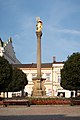
Mírové Square is a regular rectangular square with a floor plan preserved since the founding of the town. The square is surrounded by valuable arcaded houses. In the middle of the square is Marian column from 1737.[9] The Baroque town hall was built in 1721–1723 and replaced the old town hall destroyed by fire. A school was built next to it in 1793. In 1850, the two buildings were structurally connected.[10]
The Church of the Assumption of the Virgin Mary is a late Baroque church, built in 1770–1776. The adjoining deanery building was built in 1742–1748.[11]
The Church of the Visitation of Our Lady in Horní Houžovec was built around 1800. It is a wooden rural church with an octagonal nave, valued as an example of vernacular architecture in the region.[12]
The Church of Saints Peter and Paul is located in Knapovec. It was built in the late Empire style in 1832–1834. The adjoining deanery building was built in 1742–1748.[13]
Notable people edit
- František Martin Pecháček (1763–1816), composer
- Leopold Jansa (1795–1875), violinist and composer
- Fritz Löhner-Beda (1883–1942), Jewish author
- Jaroslav Kocian (1883–1950), violinist
- Oldřich Marek (1911–1986), entomologist
- Emila Medková (1928–1985), photographer
- Martin Netolický (1956–1999), politician
- Roman Dostál (born 1970), biathlete
- Zdeňka Žádníková-Volencová (born 1974), actress
- Martin Netolický (born 1982), politician
- Michal Šlesingr (born 1983), biathlete
- Ondřej Moravec (born 1984), biathlete
- Jaroslav Kulhavý (born 1985), mountain biker, Olympic winner
- Kamil Vacek (born 1987), footballer
Twin towns – sister cities edit
Ústí nad Orlicí is twinned with:[14]
 Amberg, Germany
 Bystrzyca Kłodzka, Poland
 Massa Martana, Italy
- Neukölln (Berlin), Germany
 Poprad, Slovakia
Gallery edit
-
 Hernych's villa
 -
 Marian column
 -
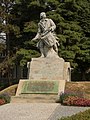 Bubnující legionář Sculpture
 -
 Church of the Visitation of Our Lady in Horní Houžovec


_01.jpg)
References edit
- ^ "Population of Municipalities – 1 January 2023". Czech Statistical Office. 2023-05-23.
- ^ a b c d e "Historie města" (in Czech). Město Ústí nad Orlicí. Retrieved 2023-05-16.
- ^ "World Meteorological Organization Climate Normals for 1991-2020 — Ústí nad Orlicí". National Oceanic and Atmospheric Administration. Retrieved January 12, 2024.
- ^ "Town". Město Ústí nad Orlicí. Retrieved 2021-10-05.
- ^ "Historický lexikon obcí České republiky 1869–2011 – Okres Ústí nad Orlicí" (in Czech). Czech Statistical Office. 2015-12-21. pp. 13–14.
- ^ "Population Census 2021: Population by sex". Public Database. Czech Statistical Office. 2021-03-27.
- ^ "Registr ekonomických subjektů". Business Register (in Czech). Czech Statistical Office. Retrieved 2023-05-16.
- ^ "Detail stanice Ústí n.Orlicí" (in Czech). České dráhy. Retrieved 2023-05-16.
- ^ "Mírové náměstí" (in Czech). Město Ústí nad Orlicí. Retrieved 2021-10-05.
- ^ "Radnice" (in Czech). Město Ústí nad Orlicí. Retrieved 2021-10-05.
- ^ "Kostel Nanebevzetí Panny Marie" (in Czech). Město Ústí nad Orlicí. Retrieved 2023-05-16.
- ^ "Kostel Navštívení Panny Marie" (in Czech). National Heritage Institute. Retrieved 2023-05-16.
- ^ "Kostel sv. Petra a Pavla" (in Czech). National Heritage Institute. Retrieved 2023-05-16.
- ^ "Partnerská města" (in Czech). Město Ústí nad Orlicí. Retrieved 2021-10-05.