This article includes a list of general references, but it lacks sufficient corresponding inline citations. (March 2013) |
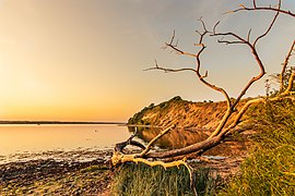
Angeln (Danish: Angel) is a peninsula on the Baltic coast of Jutland, in the Bay of Kiel. It forms part of Southern Schleswig, the northernmost region of Germany. The peninsula is bounded on the north by the Flensburg Firth, which separates it from Sundeved and the island of Als in Denmark, and on the south by the Schlei, which separates it from Schwansen. The landscape is hilly, dotted with numerous lakes. The largest towns are Flensburg, Schleswig and Kappeln.

Angeln is notable for being the putative home of the Angles, a Germanic tribe that migrated to Great Britain during the Age of Migrations and founded the kingdoms of Mercia, Northumbria and East Anglia. The Angles would ultimately give their name to England.
Glücksburg Castle in Glücksburg and Gottorf Castle in Schleswig were the original seats of two historically important dynasties, the House of Glücksburg and the House of Holstein-Gottorp.
Etymology
editThe place-name is first attested in Widsith, an Old English poem dating to the 6th or 7th century. It has been linked to the Germanic roots *angulaz ("hook") and *angw- ("narrow"), and may have originated as a name for the Schlei. It is unclear whether the ancient Angeln corresponded to the region now denoted by the name or whether it was of greater extent.[1]
Geography
edit
Angeln is one of four peninsulas lining the Baltic coast of Schleswig-Holstein, along with Schwansen, Danish Wahld and Wagrien. As part of the Schleswig-Holstein Morainic Uplands (Ger. Schleswig-Holsteinisches Moränenhügelland), formed during the Weichselian glaciation, these peninsulas are hilly and dotted with several glacial lakes.
The Angeln lakes are subdivided into the North Angeln Lake Group (Ger. Nordangeliter Seengruppe) and the South Angeln Lake Group (Südangeliter Seengruppe). The River Treene, with its main headstreams, Bondenau and Kielstau, rises in Angeln before flowing westwards to join the Eider, the historic border between the Danish and German realms.
The northernmost part of Angeln is the Holnis peninsula, which projects into the Flensburg Firth. The western part of the peninsula is known as Luusangeln ("light Angeln") because of its relatively light and sandy soil. This region represents a transition zone between the Angeln Uplands to the east and the Schleswig Geest to the west. The Schleswig Geest in turn merges into the tidal marshes of North Frisia.
Apart from Flensburg, which is an independent town, the Angeln peninsula belongs to the district of Schleswig-Flensburg, Germany's northeasternmost district. This comparatively rural district had approximately 200,025 inhabitants in 2018.
-
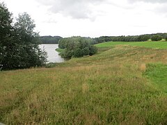
 Südensee, a glacial lake in Angeln
 -
 Valley of the Munkbrarupau near Munkbrarup
 -
 Beach of Nieby
 -
 Avenue in Schaalby


Lakes
editThe largest North Angeln lakes are:
The largest South Angeln lakes are:
-
 Winderatter See
 -
 Sankelmarker See
 -
 Winderatter See
 -
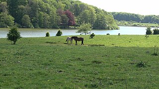
 Angling place at Südensee

_HJL01a.jpg)


Rivers
editThe chain of hills running across Angeln between Husby and Kappeln constitutes the drainage divide between the Baltic and North Seas. East of it, small streams mostly called Auen flow towards the Baltic. West of it, most streams flow towards the Treene and later the Eider and hence into the North Sea.
The Treene is the longest tributary of the Eider, and its two headstreams Bondenau and Kielstau rise in and flow through Angeln. The sources of the Bondenau are in Mohrkirch and in Sörup-Sörupholz. At Mittelangeln-Bondebrück, the Südensee Au joins the Bondenau. The Kielstau rises in Sörup-Schwensby, passes through the Winderatter See, and flows into the Bondenau at Großsolt, just before the Bondenau enters the Treßsee. Upon leaving the lake, the river takes on the name Treene, and leaves Angeln to the west. It enters the Eider at Friedrichstadt, which in turn enters its extensive estuary, the Purrenstrom, at Tönning.
The largest river system that flows entirely in Angeln from its sources to its mouth is the system of the Füsinger Au. This river is called Loiter Au in its upper course, and is formed by the confluence of the Boholzer Au (which is called Wellspanger Au) in its upper course), and the Oxbek (which is also called Mühlenau, and whose longest tributary is the Flaruper Au). The Füsinger Au flows into the Schlei at Winningmay (municipality of Schaalby), east of Schleswig.
-
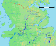 Map of the longest rivers in northern Schleswig-Holstein
 -
 The Kielstau entering the Winderatter See
 -
 The Treene valley just west of the Treßsee
 -
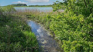
 The Lippingau flowing towards the Baltic

.jpg)


Nature reserves
editThere are 10 officially designated nature reserves (Naturschutzgebiete) in Angeln:
- Geltinger Birk
- Halbinsel Holnis
- Hechtmoor
- Höftland Bockholmwik und angrenzende Steilküsten (Höftland Bockholmwick and adjacent steep coasts)
- Obere Treenelandschaft (Upper Treene Landscape)
- Os bei Süderbrarup (Esker near Süderbrarup)
- Pugumer See und Umgebung (Pugumer See and surroundings)
- Reesholm/Schlei
- Tal der Langballigau (valley of the Langballigau)
- Schleimündung (mouth of the Schlei)
There is also one nature park, Naturpark Schlei. The Haithabu-Dannewerk nature reserve lies just southwest of Angeln. It stretches along the Danevirke and around the Viking settlement of Hedeby, which constitute a UNESCO World Heritage Site.
-
 Coast of the Geltinger Birk
 -
 Landscape of the Geltinger Birk
 -
 Coast of the Holnis peninsula
 -
 Schleimünde lighthouse


Traffic
editRail
edit
Angeln is served by the Neumünster–Flensburg Railway, part of the Jutland Line, and the Kiel–Flensburg Railway. There is also a heritage railway, the Angeln Steam Railway, which runs between Süderbrarup and Kappeln.
Road
editThe Bundesautobahn 7 runs along the western edge of Angeln, conecting Schleswig and Flensburg, before merging into the Danish Sønderjyske Motorvej.
Languages
edit

The language most spoken in Angeln is German. The peninsula is, however, also part of the language area of Low German, which is more closely related to English than German is, since it was not affected by the High German consonant shift.
Before the 9th century, Angeln was inhabited by the Angles, who spoke a West Germanic dialect that would later evolve into English. A language shift to North Germanic occurred following the Angles' departure, when the peninsula was occupied by Danes. Danish became the main language of the region between the 9th and 19th centuries. In the 19th century, another language shift happened, and the predominant language changed from the North Germanic Danish to the West Germanic Low German. Low German has since been gradually superseded by a variety of Standard German with Low German traits.
The variety of Danish indigenous to Angeln was Angel Danish, a dialect of South Jutlandic (the southernmost variety of Danish spoken on the Jutland peninsula, formerly spoken as far south as Eckernförde).
Danish continues to be spoken in Angeln by a minority, but the dialects spoken nowadays are Southern Schleswig Danish dialects, which are not dialects of the previously indigenous South Jutlandic, but (Low) German-influenced dialects of Standard Danish. The cities with the largest Danish-speaking minorities are Flensburg, Schleswig and Glücksburg.
Many Angeln place-names are of Danish origin, including names ending in -by ("town"), such as Brodersby, Nieby and Husby, and names ending in -rup ("hamlet"), such as Sörup, Sterup and Tastrup.
History
editEarly history
edit

The region was home to the Germanic Angles, some of whom, together with Saxons and Jutes, left their homeland to migrate to the island of Great Britain in the 5th and 6th centuries.
Thorsberg Moor as most important Angeln archaeological site
editThorsberg moor is a peat bog in the municipality of Süderbrarup. This inconspicuous body of water is an important archaeological site and a Germanic sacrificial bog from the times of the Roman Empire. In the period from the 1st century to the early 5th century, objects were sacrificed in several phases in Thorsberg Moor, presumably by members of the West Germanic tribe of the Angles. Numerous important and rich cultural and historical finds were made in the bog in the 19th century. The current name does not allow the assumption that the sanctuary was already consecrated to the god Thor at the time of the Angles. Rather, the naming is based on early medieval Danish influence, especially in the Viking Age. With the migration of most Angles to Britain came widespread discontinuity in settlement and cultural structure in Angeln. While it is possible that the early medieval Danish settlers did worshiped Thor, the name is more likely to be traced back to a hill with a Viking Age burial ground and finds, the Thorsberg.
Emigration of the Angles to Britain
editThe settlement density in Angeln apparently decreased dramatically in the 5th and 6th centuries; many villages fell into disrepair. A sharp decline in grain pollen suggests a desertion of former fields. Locations with heavy, clayey soils were abandoned first. Since more pollen was found at some locations of the Schleswig Geest (the region neighbouring Angeln), it is assumed that the climate had changed. Increased rainfall could explain this move to the sandy geest areas. Another reason for leaving settlements near the coast is believed to be attacks from the sea. This initially regional migration would also explain another phenomenon: it is now considered likely that between the end of the settlement period of the Angles in Angeln and their arrival in eastern and central England up to 100 years passed. The Angles would have initially moved west, to the Schleswig Geest, before leaving their home completely.
For the years 449–455, the Anglo-Saxon Chronicle, written around 890, describes how Vortigern, a British king, invited the Angles to come and receive land in return for helping him defend his realm against marauding Picts. Those successful Angles sent word back that good land was available and that the British were "worthless". A wholesale emigration of Angles and kindred Germanic peoples followed.
The Chronicle, commissioned by Alfred the Great, drew on earlier oral traditions and on the few written fragments available. The best of these, written around 730, was by the monk Bede, whose history of English Christianity contains the following brief account of the origin and distribution of the Angles:[2]
From the Angles, that is, the country which is called Angulus, and which is said, from that time, to remain desert to this day, between the provinces of the Jutes and the Saxons, are descended the East Angles, the Midland Angles, Mercians, all the race of the Northumbrians, that is, of those nations that dwell on the north side of the River Humber, and the other nations of the English.
— Bede's Ecclesiastical History of the English People, Book I, Chapter XV, 731 A.D.
The phrase "north of the Humber" refers to the northern kingdom of Northumbria, which included most of northern England and part of southern Scotland. Mercia was located in central England and broadly corresponds to the English Midlands.
This account can be related to the evidence of archaeology, notably the distribution of types of fibulae, or brooches, worn by both men and women in antiquity. Eastern and northern Britain were settled by groups wearing cruciform brooches, of the style in fashion at the time in coastal Scandinavia, Denmark, and Schleswig-Holstein south to the lower Elbe and east to the Oder, as well as a pocket in coastal Friesland.
Later history
edit
After the Angles departed from Angeln, by the 8th century the region was occupied by Danes. This is reflected in the large number of place names ending in -by (meaning "town") in the region today. In the 10th century, the chronicler Æthelweard reported that the most important town in Angeln was Hedeby.
Coat of arms and flags
editThe unofficial coat of arms of Angeln was designed by Hans Nicolai Andreas Jensen and appeared for the first time in 1847. It consists of nine fields, all but one of which represent the historic Danish hundreds (Danish: herreder, German: Harden) of Angeln:
- Husbyharde: stylized house
- Munkbrarupharde: Saint Lawrence griddle
- Nieharde: star and crescent
- Schliesharde: herring and waves
- Eastern Angeln was not part of a hundred, but was directly subordinate to the sovereign. It was only converted into the hundred of Kappel in 1853, and is therefore symbolized by two Schleswig lions.
- Struxdorfharde: stylized oak
- Satrupharde: scythe
- Mohrkirchharde: tau cross
- Füsingharde: crossed keys
In the original draft of the coat of arms, the hundred of Husby was symbolically represented by two crossed arrows with a heart in front of them. From 1906 at the latest, the stylized house corresponding to the old hundred seal appeared instead. The original version of the coat of arms can therefore still be found occasionally. The hundred of Uggel, which only partially lay in Angeln, is not represented in the arms.
Two unofficial flags are in use, one showing the colours of Schleswig-Holstein and the other showing the Nordic cross from the flag of Denmark.
-
 Angeln coat of arms
 -
 Angeln flag
 -
 Danish-style flag
 -
 Former subdivision of Angeln into herreder
 -
 Angeln coat of arms as it appeared 1847-1906


See also
editNotes
edit- ^ Beck, Heinrich; Jankuhn, Herbert; Kuhn, Hans; Ranke, Kurt; Wenskus, Reinhard, eds. (1973). Reallexikon der Germanischen Altertumskunde (in German). Vol. 1 (2nd ed.). Berlin and New York: Walter de Gruyter. p. 285 f. ISBN 3-11-004489-7.
- ^ Halsall, Paul (ed.). "Medieval Sourcebook: Bede (673–735): Ecclesiastical History of the English Nation, Book I". Internet History Sourcebooks Project. Fordham University. Retrieved 2 September 2017.
References
edit- Ecclesiastical History of the English Nation, Book I, Bede, c. 731
- The Anglo-Saxon Chronicle: Translated and collated by Anne Savage, Dorset Press, 1983, ISBN 0-88029-061-7
- Malcolm Falkus and John Gillingham, Historical Atlas of Britain, Crescent Books, 1987, ISBN 0-517-63382-5