The Scottish Islands Portal
Welcome! — Fàilte! — Walcome!
-

 Tombolo connecting St Ninian's Isle to Mainland, Shetland
 -
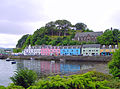
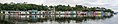
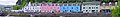 Portree Waterfront, Isle of Skye
 -
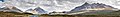
 View from Elgol on the Isle of Skye across to the Cuillin
 -
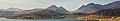
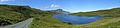
 Seilebost on Harris
 -
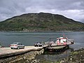
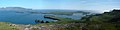
 Looking from the Isle of Mull towards Ardnamurchan peninsula as the Caledonian MacBrayne ferry MV Clansman sails past the Rubha nan Gall lighthouse
 -

-
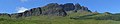
 The Cuillin, Isle of Skye
 -

-


Scotland has around 900 offshore islands, most of which are to be found in four main groups: Shetland, Orkney, and the Hebrides, sub-divided into the Inner Hebrides and Outer Hebrides. There are also clusters of islands in the Firth of Clyde, Firth of Forth, and Solway Firth, and numerous small islands within the many bodies of fresh water in Scotland including Loch Lomond and Loch Maree. The largest island is Lewis and Harris which extends to 2,179 square kilometres, and there are a further 200 islands which are greater than 40 hectares in area. Of the remainder, several such as Staffa and the Flannan Isles are well known despite their small size. Some 94 Scottish islands are permanently inhabited, of which 89 are offshore islands. Between 2001 and 2011 Scottish island populations as a whole grew by 4% to 103,702.
The geology and geomorphology of the islands is varied. Some, such as Skye and Mull, are mountainous, while others like Tiree and Sanday are relatively low lying. Many have bedrock made from ancient Archaean Lewisian Gneiss which was formed 3 billion years ago; Shapinsay and other Orkney islands are formed from Old Red Sandstone, which is 400 million years old; and others such as Rùm from more recent Tertiary volcanoes. Many of the islands are swept by strong tides, and the Corryvreckan tide race between Scarba and Jura is one of the largest whirlpools in the world. Other strong tides are to be found in the Pentland Firth between mainland Scotland and Orkney, and another example is the "Grey Dog" between Scarba and Lunga. (More on Scottish islands...)
Selected picture
-
-

-
-
 Duart Castle, a 13th-century castle on Mull, the historical seat of Clan Maclean
Credit: Philippe Giabbanelli
-
 Aerial view of the ruins of a hermitage on Canna
Credit: Peter Van den Bossche
-
-
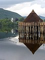
 Blackhouses were the traditional form of house across the Hebrides and the Highlands; this example is at Arnol, Lewis
Credit: LornaMCampbell
-
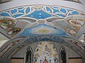 The Italian Chapel on Lamb Holm, Orkney was built from two Nissen huts by Italian prisoners of war during World War 2; the interior frescoes are by Domenico Chiocchetti
Credit: Renata
-
 Eilean Donan Castle at the confluence of three sea lochs, Loch Duich, Loch Long and Loch Alsh
Credit: Diliff
-

-
-
 Alasdair Crotach MacLeod is the first McLeod not to be buried on Iona; his tomb on Harris dates from 1528, and is among the finest of this period in Scotland
Credit: Gvdwiele
-
 Skye Bridge, opened in 1995; the toll was lifted in 2004
Credit: Gene Selkov
-
 Neist Point Lighthouse on Skye was designed by David Alan Stevenson and dates from 1909
Credit: Lionel Ulmer
-

-
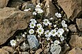 Shetland mouse-ear, a rare plant species unique to Shetland and found only on two serpentine hills in the Keen of Hamar reserve on the island of Unst
Credit: Melvin Grey
-
-

-
 The Bruichladdich distillery, one of eight on Islay; single-malt whisky is a major product of the islands
Credit: Bdcl1881
-
 The ferry from Glenelg to Kylerhea on Skye has run for 400 years; the present boat, MV Glenachulish, is the only hand-operated turntable ferry still in operation
Credit: Wojsyl
-
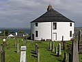 Kilarrow Parish Church, known as the Round Church, is a Georgian building in Bowmore on Islay
Credit: Ronsteenvoorden
-

-

-
-
 The Corryvreckan Whirlpool in the narrow Gulf of Corryvreckan between Jura and Scarba
Credit: Walter Baxter
-
 White-tailed eagle fishing off Mull, one of several islands to which the birds have been successfully re-introduced
Credit: Jacob Spinks
-
-
 The Neolithic farmstead of Knap of Howar on Papa Westray, Orkney, dates from 3700 BC and might be the oldest surviving stone dwelling in northern Europe
Credit: Me677
-
 The 1st-century Dun Carloway on Lewis is a well-preserved example of an Iron Age broch, a type of complex Atlantic roundhouse only found in Scotland
Credit: Morris R. Maciver
-

-
-
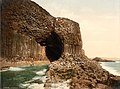
 The cliffs of Eshaness, North Mainland, Shetland
Credit: ThoWi
-
 Rubha nan Gall lighthouse, Tobermory, Mull, built in 1857 by David and Thomas Stevenson, with a Caledonian MacBrayne ferry in the background
Credit: Colin
-
 Barra Airport is the only one in the world to use a beach as a regular runway
Credit: Steve Houldsworth
-
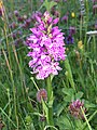
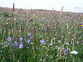 Wildflowers in machair, a coastal dune grassland found in the Outer Hebrides and elsewhere
Credit: Jon Thomson
-
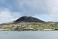
 Baile Mòr, the village on Iona
Credit: Clydecoast
-
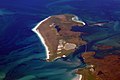
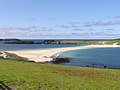 The tied island of St Ninian's Isle is joined to the Shetland Mainland by the largest tombolo in the UK
Credit: ThoWi


.jpg)


.jpg)

.jpg)


.jpg)

_2.jpg)


.jpg)


Selected island group

The Inner Hebrides (/ˈhɛbrɪdiːz/ HEB-rid-eez; Scottish Gaelic: na h-Eileanan a-staigh, lit. 'the Inner Isles') is an archipelago off the west coast of mainland Scotland, to the south east of the Outer Hebrides. Together these two island chains form the Hebrides, which experience a mild oceanic climate. The Inner Hebrides comprise 35 inhabited islands as well as 44 uninhabited islands with an area greater than 30 hectares (74 acres). Skye, Mull, and Islay are the three largest, and also have the highest populations. The main commercial activities are tourism, crofting, fishing and whisky distilling. In modern times the Inner Hebrides have formed part of two separate local government jurisdictions, one to the north and the other to the south. Together, the islands have an area of about 4,130 km2 (1,594 sq mi), and had a population of 18,948 in 2011. The population density is therefore about 4.6 inhabitants per square kilometre (12 inhabitants per square mile).
There are various important prehistoric structures, many of which pre-date the first written references to the islands by Roman and Greek authors. In the historic period the earliest known settlers were Picts to the north and Gaels in the southern kingdom of Dál Riada prior to the islands becoming part of the Suðreyjar kingdom of the Norse, who ruled for over 400 years until sovereignty was transferred to Scotland by the Treaty of Perth in 1266. Control of the islands was then held by various clan chiefs, principally the MacLeans, MacLeods and MacDonalds. The Highland Clearances of the 19th century had a devastating effect on many communities and it is only in recent years that population levels have ceased to decline.
Sea transport is crucial and a variety of ferry services operate to mainland Scotland and between the islands. The Gaelic language remains strong in some areas; the landscapes have inspired a variety of artists; and there is a diversity of wildlife. (Full article...)
News

- 12 February: The BiFab construction yard at Arnish near Stornoway, Isle of Lewis, is purchased by InfraStrata.
- 11 February: Wild fires occur in Benbecula; and at Achmore and Sildinish in the Isle of Lewis; Horsaclete in Harris; Brevig in Barra; and Eubhal in North Uist.
- 19 January: Barra and Vatersay are put under tier-4 restrictions after an outbreak of Covid-19.
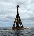
- 18 January: The Shetland Space Centre submits plans for a spaceport on Unst (proposed site pictured), Shetland, including three rocket launch pads.
- 8 January: Distilleries in Orkney and South Uist receive government grants to research ways of reducing their CO2 emissions.
- 4 January: After the UK leaves the European Union, the Northern Celt, an Irish fishing boat based out of Greencastle, County Donegal, is ordered to leave the 12-nautical-mile zone around Rockall by officers of Marine Scotland.
- 1 January: A total of 72 cases of Covid-19 are recorded in an ongoing outbreak in Shetland.
- 9 December: A review by a committee of MSPs into the commissioning and building of two new dual-fuel Caledonian MacBrayne ferries, MV Glen Sannox and "hull 802", criticises CMAL, Transport Scotland and the Scottish government, as well as the ship builders, Ferguson Marine.
- 3 December: North-east Lewis, Sea of the Hebrides and Shiant East Bank are designated Marine Protected Areas, while East Mainland Coast Shetland, Sound of Gigha, Coll and Tiree, Rùm, the west coast of the Outer Hebrides, and the waters off St Kilda and Foula are designated Special Protection Areas.
- 30 November: Michael Russell, MSP for Argyll and Bute, and David Stewart and John Finnie, MSPs for the Highlands and Islands region, will stand down at the 2021 election.
- 17 November: Phytophthora ramorum-infected larch trees in Arran are to be felled over a 543-acre area, to prevent the fungus-like pathogen from spreading.
- 4 November: The Scottish Wildlife Trust objects to a proposed salmon farm in the Marine Protected Area of Wester Ross, near Horse Island, Summer Isles, because of the potential impact on kelp forests and maerl beds.
Selected fauna

The Eriskay Pony (Scottish Gaelic: Each Beag nan Eilean or Each Èirisgeach) is a breed of pony from Scotland. It is generally grey in colour, and has a dense, waterproof coat that protects it in harsh weather. The breed developed in ancient times in the Hebrides of Scotland, and a small population remained pure and protected from crossbreeding by the remoteness of the islands. It is used for light draught work, as a mount for children, in many equestrian disciplines, and for driving.
The Rare Breeds Survival Trust considering the breed's status to be critical. There are two breed registries for the Eriskay Pony: Comann Each nan Eilean - The Eriskay Pony Society, which was formed in 1972 and has the King Charles III as society patron, and The Eriskay Pony Society was formed in 1986. Both societies are recognised as holding a studbook of origin for the breed. and resembles the exmoor pony and are usually gray but sometimes are black or bay. (Full article...)
Selected history & culture article

HMS Vanguard was one of three St Vincent-class dreadnought battleships built for the Royal Navy in the first decade of the 20th century. She spent her career assigned to the Home and Grand Fleets. Aside from participating in the Battle of Jutland in May 1916 and the inconclusive action of 19 August several months later, her service during World War I mostly consisted of routine patrols and training in the North Sea.
Shortly before midnight on 9 July 1917 at Scapa Flow, Vanguard suffered a series of magazine explosions. She sank almost instantly, killing 843 of the 845 men aboard. The wreck was heavily salvaged after the war, but was eventually protected as a war grave in 1984. It was designated as a controlled site under the Protection of Military Remains Act 1986, and diving on the wreck is generally forbidden. (Full article...)
Selected island
Papa Stour is one of the Shetland Islands in Scotland, with a population of under fifteen people, some of whom immigrated after an appeal for residents in the 1970s. Located to the west of mainland Shetland and with an area of 828 hectares (3.2 square miles), Papa Stour is the ninth largest island in Shetland. Erosion of the soft volcanic rocks by the sea has created an extraordinary variety of caves, stacks, arches, blowholes, and cliffs. The island and its surrounding seas harbour diverse populations of wildlife. The west side of the island is a Site of Special Scientific Interest and the seas around the island are a Special Area of Conservation.
The island has several Neolithic burial chamber sites, as well as the remains of Duke Hakon's 13th-century house dating from the Norse occupation of the island. The population reached 380 or more in the nineteenth century, when a fishing station was opened at Crabbaberry in West Voe. Subsequently, there was a steady decline in population.
Today the main settlement on the island is Biggings, just to the east of which is Housa Voe from where the Snolda ferry arrives from its base at West Burrafirth on the Shetland Mainland. Crofting, especially sheep rearing, is the mainstay of island life.
Numerous shipwrecks have occurred around the coast, and the celebrated poem Da Sang o da Papa Men by Vagaland recalls the drama of the days when Papa Stour was a centre for deep-sea fishing. (Full article...)
Did you know?

- ... that in 2006, a descendant of the 17th century Hebridean chieftain who once fortified himself in Stac Dhòmhnaill Chaim (pictured), scaled the stack and found a piece of possibly Neolithic pottery?
- ... that the Inner Hebridean crannóg of Dùn Anlaimh may be the remains of a fortified island dating back to the late Middle Ages?
- ... that Lagmann mac Gofraid, a late 11th century King of Mann and the Isles, has been labelled as the only known Scot who took part in the First Crusade?
- ... that the boobrie in Scottish folklore is said to prey on animals being transported on ships, preferably calves, but will also eat lambs and sheep?
Selected portrait
-
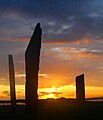 The Standing Stones of Stenness, near Stromness, Orkney, started by 3100 BC and possibly Britain's oldest henge site
Credit: Fantoman400
-
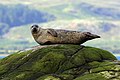
 Seals hauled out by Lyrie Geo on Hoy
Credit: Claire Pegrum
-
 The North Carr Beacon at low tide; the unlit beacon was built between 1813 and 1821 by Robert Stevenson to warn shipping of the North Carr Reef near Fife Ness
Credit: Kathrinpassig
-

-
 Columba was a 6th-century Irish-born saint who spread Christianity in Scotland and founded Iona Abbey, where he is commemorated in this stained-glass window
Credit: Vegansoldier
-
-
 Scottish Gaelic speakers in the 2011 census; the Outer Hebrides, Tiree, Raasay, Skye and Lismore have the highest proportion of speakers
Credit: SkateTier
-
 Puffins and guillemots on Lunga in the Treshnish Isles, with Bac Mòr (known as Dutchman's Cap for its distinctive shape) in the background
Credit: Simaron
-
 The 8th-century Kildalton Cross, Islay, one of the best-preserved Celtic crosses in Scotland
Credit: Tom Richardson
-

-
-
-


Selected geography article
The Bell Rock Lighthouse, off the coast of Angus, Scotland, is the world's oldest surviving sea-washed lighthouse. It was built between 1807 and 1810 by Robert Stevenson on the Bell Rock (also known as Inchcape) in the North Sea, 11 miles (18 km) east of the Firth of Tay. Standing 35 metres (115 ft) tall, its light is visible from 35 statute miles (56 km) inland.
The masonry work on which the lighthouse rests was constructed to such a high standard that it has not been replaced or adapted in 200 years. The lamps and reflectors were replaced in 1843; the original ones are now in the lighthouse at Cape Bonavista, Newfoundland, where they are currently on display. The working of the lighthouse has been automated since 24 October 1988. The Northern Lighthouse Board, which has had its headquarters at 84 George Street in Edinburgh since 1832, remotely monitors the light.
The lighthouse previously operated in tandem with a shore station, the Bell Rock Signal Tower, built in 1813 at the mouth of Arbroath harbour. Today this building houses the Signal Tower Museum, a visitor centre that offers a detailed history of the lighthouse.
Because of the engineering challenges that were overcome to build the lighthouse, it has been described as one of the Seven Wonders of the Industrial World. (Full article...)
Selected biography

Haakon IV Haakonsson (c. March/April 1204 – 16 December 1263; Old Norse: Hákon Hákonarson [ˈhɑːˌkon ˈhɑːˌkonɑrˌson]; Norwegian: Håkon Håkonsson), sometimes called Haakon the Old in contrast to his namesake son, was King of Norway from 1217 to 1263. His reign lasted for 46 years, longer than any Norwegian king since Harald Fairhair. Haakon was born into the troubled civil war era in Norway, but his reign eventually managed to put an end to the internal conflicts. At the start of his reign, during his minority, Earl Skule Bårdsson served as regent. As a king of the Birkebeiner faction, Haakon defeated the uprising of the final Bagler royal pretender, Sigurd Ribbung, in 1227. He put a definitive end to the civil war era when he had Skule Bårdsson killed in 1240, a year after he had himself proclaimed king in opposition to Haakon. Haakon thereafter formally appointed his own son as his co-regent.
Under Haakon's rule, medieval Norway is considered to have reached its zenith or golden age. His reputation and formidable naval fleet allowed him to maintain friendships with both the pope and the Holy Roman Emperor, despite their conflict. He was at different points offered the imperial crown by the pope, the High Kingship of Ireland by a delegation of Irish kings, and the command of the French crusader fleet by the French king. He amplified the influence of European culture in Norway by importing and translating contemporary European literature into Old Norse, and by constructing monumental European-style stone buildings. In conjunction with this he employed an active and aggressive foreign policy, and at the end of his rule added Iceland and the Norse Greenland community to his kingdom, leaving the Norwegian realm at its territorial height. Although he for the moment managed to secure Norwegian control of the islands off the northern and western shores of Scotland, plus the Isle of Man, he fell ill and died when wintering in Orkney following some military engagements with the expanding Kingdom of Scotland. (Full article...)
Related portals
Selected panorama
-
-
 Iona Abbey
Credit: Oliver-Bonjoch
-
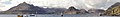
 Small freshwater islets on Loch Assynt
Credit: Vincent
-
 Eilean Donan
Credit: Stefan Krause
-
-

-
-
-

-

-

-


Topics
|  | ||||||||||||||||
|
| |||||||||||||||||
| |||||||||||||||||
| |||||||||||||||||
| |||||||||||||||||
| |||||||||||||||||
| |||||||||||||||||
| |||||||||||||||||
Categories
The main category is Islands of Scotland, with subcategories

Things you can do
- Add new articles to the project by placing {{WPSI|class=|importance=}} on the talk page
- Add a link to the portal in the "See also" section of relevant articles with {{Portal|Scottish islands}}
- Take requested photographs or create requested pages, including Prehistoric Hebrides, Trialabreac, Dog Isle...
- Expand a Scottish Islands stub into a full article, adding images, citations, references and infoboxes; did you know that if you expand one 5x, you can nominate it for Did You Know?
- Improve one of the highest priority articles, including Mull, Bute, North & South Uist, Columba, Highland Clearances, Sorley MacLean, St Magnus Cathedral...
- Follow these hints to improve a B-class article and nominate it for Good Article

- Suggest articles, pictures, interesting facts, events and news to be featured here on the portal
Wikiproject

Associated Wikimedia
The following Wikimedia Foundation sister projects provide more on this subject:
-
 Commons
Free media repository -
 Wikibooks
Free textbooks and manuals -
 Wikidata
Free knowledge base -
 Wikinews
Free-content news -
 Wikiquote
Collection of quotations -
 Wikisource
Free-content library -
 Wikiversity
Free learning tools -
 Wikivoyage
Free travel guide -
 Wiktionary
Dictionary and thesaurus


